Advertisements
Advertisements
प्रश्न
Explain the situations represented by the following distance-time graph.

Advertisements
उत्तर
Here x-axis represents time and y-axis represents distance.
In the first graph, we observe that when time changes, distance also varies at the same rate.
When we move along time axis away from the origin, then the graph is strictly increasing.
Hence, the object is moving at a uniform speed.
APPEARS IN
संबंधित प्रश्न
Decide which of the following statements is true and which is false. Give reasons for your answer.
Points whose x and y coordinates are equal, lie on a line passing through the origin.
A point in which the x-coordinate is zero and y-coordinate is non-zero will lie on the ______.
The x-coordinate of any point lying on the y-axis will be ______.
The distance of the point (3, 5) from the y-axis is 5.
Match the ordinates of the points given in Column A with the items mentioned in Column B.
| Column A | Column B |
| (a) (7, 0) | (i) The ordinate is double the abscissa. |
| (b) (11, 11) | (ii) The ordinate is zero. |
| (c) (4, 8) | (iii) The ordinate is equal to the abscissa. |
| (d) (6, 2) | (iv) The abscissa is double the ordinate. |
| (e) (0, 9) | (v) The abscissa is triple the ordinate. |
| (f) (6, 3) | (vi) The abscissa is zero. |
Study the given map of a zoo and answer the following questions.
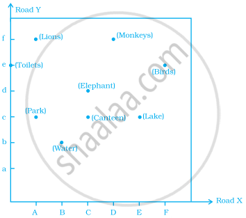
- Give the location of lions in the zoo.
- (D, f) and (C, d) represent locations of which animals in the zoo?
- Where are the toilets located?
- Give the location of canteen.
Write the y-coordinate (ordinate) of the given point.
(3, 5)
Plot the given points on a graph sheet and check if the points lie on a straight line. If not, name the shape they form when joined in the given order.
(4, 2), (2, 4), (3, 3), (5, 4)
Extend the line segment on both sides to meet the coordinate axes. What are the coordinates of the points where this line meets the x-axis and the y-axis?
