Advertisements
Chapters
1: Earth as a Planet
▶ 2: Geographic Grid: Latitudes and Longitudes
3: Rotation and Revolution
UNIT 2 - Structure of the Earth
4: Earth’s Structure
5: Landforms of the Earth
6: Rocks
7: Volcanoes
8: Earthquakes
9: Weathering
10: Denudation
UNIT 3 - Hydrosphere
11: Hydrosphere
UNIT 4 - Atmosphere
12: Composition and Structure of the Atmosphere
13: Insolation
14: Atmospheric Pressure and Winds
15: Humidity
UNIT 5 - Pollution
16: Pollution
17: Sources of Pollution
18: Effects of Pollution
19: Preventive Measures
UNIT 6 - Natural Regions of the World
20: Natural Regions of the World
![Morning Star solutions for Total Geography [English] Class 9 ICSE chapter 2 - Geographic Grid: Latitudes and Longitudes - Shaalaa.com](/images/total-geography-english-class-9-icse_6:383837e303f247e39353ecf0a3404fb4.jpg "Morning Star solutions for Total Geography [English] Class 9 ICSE chapter 2 - Geographic Grid: Latitudes and Longitudes")
Advertisements
Solutions for Chapter 2: Geographic Grid: Latitudes and Longitudes
Below listed, you can find solutions for Chapter 2 of CISCE Morning Star for Total Geography [English] Class 9 ICSE.
Morning Star solutions for Total Geography [English] Class 9 ICSE 2 Geographic Grid: Latitudes and Longitudes EXERCISES [Pages 24 - 28]
Choose the correct option:
The imaginary lines running east to west on a globe are called ______ while those running north to south are called ______.
Latitude, Longitude
Longitude, Latitude
Equator, Prime Meridian
All of the above
Name the criss-crossing lines on a globe that form a framework.
Geographic Framework
Geographic Grid
Geographic Matrix
Geographic Lines
Which of the following is true about the lines of Latitude?
They are imaginary lines
They are parallel to the Equator
They reduce in length as we go towards the poles.
All of the above
In each hemisphere for which latitude the length of the circle is half the length of the Equator?
30°
45°
60°
90°
The total number of the parallels of Latitude are ______.
180
182
183
181
The poles are located at what angular distance from the Equator?
90°
45°
60°
0°
Which of the following heat zones are correct?
Frigid Zone: 661/2°N to 661/2°S
Temperate Zone: 90°N to 90°S
Torrid Zone: 23Y2°N to 23 Y2°S
All of the above
Which of the following is true about lines of longitude?
They run parallel to the Prime Meridian.
They are full circles.
They are 360 lines at 1° interval.
All of the above.
See the above figure and answer the following question.
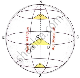
What would be the value of angle AOB?
40°
20°
10°
140°
See the above figure and answer the following question.
The circle through EQ is a ______.
Great circle
Small circle
Semi-circle
Both (a) and (b)
See the above figure and answer the following question.
Identify the relationship between length of the Prime Meridian and that of 40° Meridian.
≥
<
=
≤
Assertion (A): 1° angular distance of the parallels of latitudes is roughly equal to 111 km.
Reason (R): The poles are each located at 90° angular distance north or south of the Equator.
Both A and R are true and R is the correct explanation of A.
Both A and R are true but R does not explain A.
A is true but R is false.
A is false but R is true.
The distance between two lines of longitude is maximum at which latitude?
Tropic of Cancer
North Pole
Equator
Arctic circle
Assertion (A): All places on a particular meridian will have noon at the same time.
Reason (R): The sun crosses a meridian at noon.
Both A and R are true and R is the correct explanation of A.
Both A and R are true but R does not explain A.
A is true but R is false.
A is false but R is true.
The Earth has been divided into how many Time Zones?
48
20
12
24
What is Standard Time?
Uniform time based on a central meridian.
Time at 0° longitude
Time at 82°30'E
Time at 7½° longitudes at 12 noon.
Which of the following is true about the International Date Line?
It goes zig-zag at two points.
The date changes as one moves across it.
It is opposite the Prime Meridian.
All of the above
Assertion (A): For each 1° longitude towards the East, 4 minutes are to be added and each 1° longitude towards the West, 4 minutes are to be subtracted.
Reason (R): The earth rotates on its axis from East to West.
Both A and R are true and R is the correct explanation of A.
Both A and R are true but R does not explain A.
A is true but R is false.
A is false but R is true.
I travelled from Tokyo, Japan to Alaska, USA. I was very sad to lose a day. How did this happen?
Crossed the IDL
Crossed the Pacific Ocean
Crossed over to another country
Crossed the Prime Meridian
It was midnight at the Fiji Islands. What would be the time in London?
8:00 am
12:00 noon
8:00 pm
None of the above
A great circle is a circle drawn on the surface of a sphere with radius ______.
equal to the radius of the sphere.
equal to half the radius of the sphere.
larger than the radius of the sphere.
less than the radius of the sphere.
Which of the following are great circles?
Lines of Longitudes
Lines of Latitudes
Equator
Both Lines of Longitudes and Equator
Assertion (A): There is a time difference of a full day on crossing the ID L.
Reason (R): It is diametrically opposite the Greenwich Meridian.
Both A and R are true and R is the correct explanation of A.
Both A and R are true but R does not explain A.
A is true but R is false.
A is false but R is true.
Assertion (A): Great circles are used to find the shortest distance between any two points on the earth's surface.
Reason (R): Great circle routes take into account weather or political restrictions.
Both A and R are true and R is the correct explanation of A.
Both A and R are true but R does not explain A.
A is true but R is false.
A is false but R is true.
Short Answer Questions
What is a geographic grid?
How does the geographic grid serve the same purpose as co-ordinates on a graph?
What are the lines of latitude?
What are lines of longitude?
Who devised the lines of latitude and longitude?
Mention two characteristics of lines of latitude.
Name the two hemispheres of the earth made by the Equator.
Name the thermal zones of the earth.
List any two uses of the lines of latitude.
Express 1° angular distance in kilometers.
With the help of a diagram, show the important lines of latitude.
Which line is known as the Prime Meridian?
State the importance of the Prime Meridian.
How can the general climate of an area be described with the help of the lines of latitudes?
Which line of longitude is used to fix the World Standard Time? State its value in degrees.
State the longitudinal value in degrees of Indian Standard Meridian.
List any two characteristics of the Great Circles.
List any two uses of the Great Circles.
What are the Great Circle Routes?
State the importance of Great Circle Routes.
Structured Questions
State the five lines of latitude.
What is the significance of these lines of latitude?
Give a geographical reason for lines of latitude are called parallels of latitude.
Give a geographical reason for lines of latitude are not of equal length.
Give a geographical reason for lines of latitude carve out the heat zones of the earth.
With the help of a diagram, show the important lines of latitude.
What are lines of longitude?
State the use of the lines of longitude in relation to distance and time.
Give a reason for the lines of longitude are also called Meridians of longitude.
Give a geographical reason for the lines of longitude are of same length.
Give a reason for the diametrically opposite lines of longitude and the Equator are called Great Circles.
Draw a well labelled diagram to show that places on the same longitude have the same time.
State the meaning of the International Date Line.
State with an example how time lost or gained is computed with reference to the International Date Line.
Give a reason the international date line deviates and goes zig-zag near some Islands in the Pacific ocean.
Give a reason the greenwich time is called Greenwich Mean Time.
Give a reason the great Circles are the shortest routes between two places.
State with one practical example how is time of a place found with the help of longitudes.
Time-related Questions: Answer the following questions:
An important programme was to be broadcast from Mumbai at 7.30 p.m. This was heard by some Indian sailors near Ivory Coast in West Africa at 20°W longitude. What was the local time there?
What is the longitude of a place where the local time 1:15 p.m. when it is 4 a.m. at Chicago (88°W)?
Calculate the time at Durban (longitude 30°E) when the time is 7.00 a.m. at New York (75°W).
Calculate the longitude of a place where the local time is 6.00 a.m. when the time is 9.00 p.m. at New Delhi on longitude 77° E.
Calculate the local time in Singapore (104°E) when it is 6.00 p.m. at Greenwich.
Calculate the location of a place where the local time is noon when it is 7.30 p.m. at Greenwich.
What is the time and day at Mumbai (73°E) when it is Sunday at 10.30 p.m. at Shillong (92°E)? Give a reason to support your answer.
Thinking Skills
Find the latitude of your city and state how has this influenced the climate of your city.
Your home town is located at a place which receives the slanting rays of the sun. How is the temperature of your home town different from your boarding school, located at a place that receives the vertical rays of the Sun?
Find out the name of the country which has the maximum number of time zones in the world. What is reason behind a country having many time zones and others like India have just one time zone.
When you were waiting to welcome New Year in India on December 31, some countries of the world like Australia, New Zealand and Japan have already welcomed New Year. What is the reason for this?
Look at the map of the Time Zones and answer the following questions:

- What is the Longitudinal degree of IST ______?
- If it is 2 a.m. IST what will be the Time at Tokyo ______, London ______, San Francisco ______?
- Name the place which is diametrically opposite of India.
- Is the Indian Standard Time ahead of San Francisco Time? Give reasons for your answer.
Solutions for 2: Geographic Grid: Latitudes and Longitudes
Morning Star solutions for Total Geography [English] Class 9 ICSE chapter 2 - Geographic Grid: Latitudes and Longitudes
Shaalaa.com has the CISCE Mathematics Total Geography [English] Class 9 ICSE CISCE solutions in a manner that help students grasp basic concepts better and faster. The detailed, step-by-step solutions will help you understand the concepts better and clarify any confusion. Morning Star solutions for Mathematics Total Geography [English] Class 9 ICSE CISCE 2 (Geographic Grid: Latitudes and Longitudes) include all questions with answers and detailed explanations. This will clear students' doubts about questions and improve their application skills while preparing for board exams.
Further, we at Shaalaa.com provide such solutions so students can prepare for written exams. Morning Star textbook solutions can be a core help for self-study and provide excellent self-help guidance for students.
Concepts covered in Total Geography [English] Class 9 ICSE chapter 2 Geographic Grid: Latitudes and Longitudes are The Shape of the Earth, Earth as the Home of Humankind and the Conditions that Exist, Earth Grid (Geographic Grid), Concept of Latitudes, Concept of Longitudes, The Great Circles, Revolution of the Earth, Rotation and Revolution, Planet.
Using Morning Star Total Geography [English] Class 9 ICSE solutions Geographic Grid: Latitudes and Longitudes exercise by students is an easy way to prepare for the exams, as they involve solutions arranged chapter-wise and also page-wise. The questions involved in Morning Star Solutions are essential questions that can be asked in the final exam. Maximum CISCE Total Geography [English] Class 9 ICSE students prefer Morning Star Textbook Solutions to score more in exams.
Get the free view of Chapter 2, Geographic Grid: Latitudes and Longitudes Total Geography [English] Class 9 ICSE additional questions for Mathematics Total Geography [English] Class 9 ICSE CISCE, and you can use Shaalaa.com to keep it handy for your exam preparation.
