Advertisements
Advertisements
Question
The y-coordinate of the point (2, 4) is ______.
Advertisements
Solution
The y-coordinate of the point (2, 4) is 4.
Explanation:
In the ordered pair (2, 4), i.e. coordinates of a point, the second number is called as the y-coordinate of the point.
Hence, the y-coordinate of (2, 4) is 4
APPEARS IN
RELATED QUESTIONS
State whether True or False. Correct those are false.
A point whose x coordinate is zero and y-coordinate is non-zero will lie on the y-axis.
In the given graph the coordinates of point x are ______.
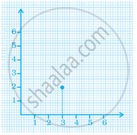
A point in which the x-coordinate is zero and y-coordinate is non-zero will lie on the ______.
In the point (4, 7), 4 denotes the ______.
The ordinate of a point is its distance from the y-axis.
The y-coordinate of any point lying on the x-axis will be zero.
Match the ordinates of the points given in Column A with the items mentioned in Column B.
| Column A | Column B |
| (a) (7, 0) | (i) The ordinate is double the abscissa. |
| (b) (11, 11) | (ii) The ordinate is zero. |
| (c) (4, 8) | (iii) The ordinate is equal to the abscissa. |
| (d) (6, 2) | (iv) The abscissa is double the ordinate. |
| (e) (0, 9) | (v) The abscissa is triple the ordinate. |
| (f) (6, 3) | (vi) The abscissa is zero. |
Plot the given points on a graph sheet and check if the points lie on a straight line. If not, name the shape they form when joined in the given order.
(4, 2), (2, 4), (3, 3), (5, 4)
Draw the line graph using suitable scale to show the annual gross profit of a company for a period of five years.
| Year | 1st | 2nd | 3rd | 4th | 5th |
| Gross Profit (in Rs) |
17,00,000 | 15,50,000 | 11,40,000 | 12,10,000 | 14,90,000 |
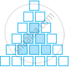
Sonal and Anmol then made another sequence of the designs. Three of the designs are shown below.
 |
 |
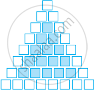 |
(a) Complete the table.
| Rows, r | 4 | 6 | 8 |
| Number of white Tiles, w | 9 | ||
| Number of Purple Tiles, p | 1 |
(b) Draw a graph of rows and number of white tiles. Draw another graph of the number of rows and the number of purple tiles. Put the number of rows on the horizontal axis.
(c) Which graph is linear?
