Advertisements
Advertisements
Question
Mark the following in the outline map of India. Write the names and given index.
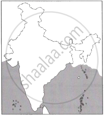
- Lakshadweep Islands
- Coromandel Coast
- Gulf of Khambhat
- Any Major Port
- Thar Desert
- Palk Strait
Advertisements
Solution

APPEARS IN
RELATED QUESTIONS
Answer the following question briefly.
What is meant by a water divide? Give an example.
Give Reasons:
West flowing rivers do not form deltas.
Give Reasons:
The river Godavari is often referred as Vridha Ganga.
State the west following rivers of India.
The Indus river flows into Pakistan through ______.
The deltaic region of lower Ganga, the uplands are known as ______.
The Gangetic plain was formed due to ______.
The rivers passed their ways by eroding their ______ when Himalayas lifted themselves high.
On an outline map of India mark and label the following lakes: Chilika, Sambhar, Wular, Pulicat, Kolleru.
With the help of the given statistical data prepare a simple bar graph and answer the following questions.
| Ganga River | Amazon River | |
| Total catchment area (in sq.km) | 10,16,124 | 70,50,000 |
| The total length of the river (in km) | 2,525 | 6400 |
| Water discharge (Cu.m. per sec) | 16,648 | 2,09,000 |
- What is the total length of the river Ganges?
- What is inferred from the graph?
- What can be said about the water discharge of the Amazon river?
