Advertisements
Advertisements
Question
| Stations | Latitude | Altitude (Metres) | Jan. | Feb. | Mar. | Apr. | May. | Jun. | July. | Aug. | Sep. | Oct. | Nov. | Dec. | Annual Rainfall |
|
Temperature (°C) |
20.5 |
22.7 |
25.2 |
27.1 |
26.7 |
24.2 |
23.0 |
23.0 |
23.1 |
22.9 |
18.9 |
20.2 |
|||
| Bengaluru | 12°58'N | 909 |
|
|
|
||||||||||
| Rainfall (cm) | 0.7 | 0.9 | 1.1 | 4.5 | 10.7 | 7.1 | 11.1 | 13.7 | 16.4 |
15.3 |
6.1 |
1.3 |
88.9 | ||
|
Temperature (°C) |
24.4 |
24.4 |
26.7 |
28.3 |
30.0 |
28.9 |
27.2 |
27.2 |
27.2 |
27.8 |
27.2 |
25.0 |
|||
|
Mumbai |
19° N | 11 |
|
|
|
|
|
|
|
|
|
|
|
|
|
|
Rainfall (cm) |
0.2 |
0.2 |
– |
– |
1.8 |
50.6 |
61.0 |
36.9 |
26.9 |
4.8 |
1.0 |
– |
183.4 | ||
|
Temperature (°C) |
19.6 |
22.0 |
27.1 |
30.1 |
30.4 |
29.9 |
28.9 |
28.7 |
28.9 |
27.6 |
23.4 |
19.7 |
|||
|
Kolkata |
22°34'N | 6 |
|
|
|
|
|
|
|
|
|
|
|
|
|
|
Rainfall (cm) |
1.2 |
2.8 |
3.4 |
5.1 |
13.4 |
29.0 |
33.1 |
33.4 |
25.3 |
12.7 |
2.7 |
0.4 |
162.5 | ||
|
Temperature (°C) |
14.4 |
16.7 |
23.3 |
30.0 |
33.3 |
33.3 |
30.0 |
29.4 |
28.9 |
25.6 |
19.4 |
15.6 |
|||
|
Delhi |
29° N | 219 |
|
|
|
|
|
|
|
|
|
|
|
|
|
|
Rainfall (cm) |
2.5 |
1.5 |
1.3 |
1.0 |
1.8 |
7.4 |
19.3 |
17.8 |
11.9 |
1.3 |
0.2 |
1.0 |
67.0 | ||
|
Temperature (°C) |
16.8 |
19.2 |
26.6 |
29.8 |
33.3 |
33.9 |
31.3 |
29.0 |
20.1 |
27.0 |
20.1 |
14.9 |
|||
|
Jodhpur |
26°18'N | 224 |
|
|
|
|
|
|
|
|
|
|
|
|
|
|
Rainfall (cm) |
0.5 |
0.6 |
0.3 |
0.3 |
1.0 |
3.1 |
10.8 |
13.1 |
5.7 |
5.7 |
0.2 |
0.2 |
36.6 | ||
|
Temperature (°C) |
24.5 |
25.7 |
27.7 |
30.4 |
33.0 |
32..5 |
31.0 |
30.2 |
29.8 |
28.0 |
25.9 |
24.9 |
|||
|
Chennai |
13°4'N | 7 |
|
|
|
|
|
|
|
|
|
|
|
|
|
|
Rainfall (cm) |
4.6 |
1.3 |
1.3 |
1.8 |
3.8 |
22.2 |
8.7 |
11.3 |
11.9 |
30.6 |
35.0 |
0.2 |
128.6 | ||
|
Temperature (°C) |
21.5 |
23.9 |
28.3 |
32.7 |
35.5 |
32.0 |
27.7 |
27.3 |
27.9 |
26.7 |
23.1 |
20.7 |
|||
|
Nagpur |
21°9'N | 312 |
|
|
|
|
|
|
|
|
|
|
|
|
|
|
Rainfall (cm) |
1.1 |
2.3 |
1.7 |
1.6 |
2.1 |
22.2 |
37.6 |
28.6 |
18.5 |
5.5 |
2.0 |
13.9 |
124.2 | ||
|
Temperature (°C) |
9.8 |
11.3 |
15.9 |
18.5 |
19.2 |
20.5 |
21.1 |
20.9 |
20.9 |
17.2 |
13.3 |
10.4 |
|||
|
Shillong |
24°34'N | 1461 |
|
|
|
|
|
|
|
|
|
|
|
|
|
|
Rainfall (cm) |
1.4 |
2.9 |
5.6 |
14.6 |
29.5 |
47.6 |
35.9 |
34.3 |
30.2 |
18.8 |
3.8 |
1.0 |
225.3 | ||
|
Temperature (°C) |
26.7 |
27.3 |
28.3 |
28.7 |
28.6 |
26.6 |
26.2 |
26.2 |
26.5 |
26.7 |
26.6 |
26.5 |
|||
|
Thiruvananthapuram |
8°29'N | 61 |
|
|
|
|
|
|
|
|
|
|
|
|
|
|
Rainfall (cm) |
2.3 |
2.1 |
3.7 |
10.6 |
20.8 |
35.6 |
22.3 |
14.6 |
13.8 |
27.3 |
20.6 |
7.5 |
181.2 | ||
|
Temperature (°C) |
−8.5 |
−7.2 |
−0.6 |
6.1 |
10.0 |
14.4 |
17.2 |
16.1 |
12.2 |
6.1 |
0.0 |
−5.6 |
|||
|
Leh |
34°N | 3506 |
|
|
|
|
|
|
|
|
|
|
|
|
|
|
Rainfall (cm) |
1.0 |
0.8 |
0.8 |
0.5 |
0.5 |
0.5 |
1.3 |
1.3 |
0.8 |
0.5 |
– |
0.5 |
8.5 |
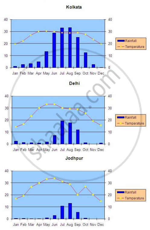
In above Table the average mean monthly temperatures and amounts of rainfall of ten representative stations have been given. It is for you to study on your own and convert them into ‘temperature and rainfall’ graphs. A glance at these visual representations will help you to grasp instantly the similarities and differences between them. One such graph (Figure 1) is already prepared for you. See if you can arrive at some broad generalisations about our diverse climatic conditions. 
Advertisements
Solution



RELATED QUESTIONS
Name the following:
The winds that bring heavy rain to Cherrapunji.
Give reasons for the following:
When the Malabar Coast is receiving heavy rainfall in July, the Tamil Nadu coast is comparatively dry.
Which parallel of latitude divides India into the northern and southern halves.
‘Rainfall decreases as one travels up the Ganges Valley.’ Why?
State the climatic significance of the Himalayas to the people of South Asia.
Or
Describe the two ways in which the Himalayas influence the climate of India.
Why does Kanyakumari experience an equable climate?
Kanyakumari is the first to receive the south-west monsoon stream and the last to see its retreat.
A cricket match at Chennai (Madras) from October 24 to 28 had to be abandoned because of bad weather. As a student of geography provide an explanation and the technical name of this Season in India, the atmospheric pressure conditions over the Bay of Bengal during this part of the year and the typical rainfall experienced in Chennai (Madras) city.
Study the table given below and answer the questions that follow:
| Station | Month | J | F | M | A | M | J | J | A | S | O | N | D |
| A | Temperature in Degree C. | 14.4 | 16.7 | 23.3 | 30.0 | 33.3 | 33.3 | 30.0 | 29.4 | 28.9 | 25.6 | 19.4 | 15.6 |
| Rainfall in cm | 2.5 | 1.5 | 1.3 | 10 | 1.8 | 7.4 | 19.3 | 17.8 | 11.9 | 1.3 | 0.2 | 1.0 | |
| B | Temperature in Degree C. | 24.4 | 24.4 | 26.7 | 28.3 | 300 | 28.9 | 27.2 | 27.2 | 27.2 | 27.8 | 27.2 | 25.0 |
| Rainfall in cm | 0.2 | 0.2 | 0.3 | 10 | 1.8 | 50.6 | 61.0 | 24.8 | 24.8 | 24.8 | 1.0 | 0.7 |
(i) Calculate the annual rainfall in station A.
(ii) What is the annual range of temperature in station B?
(iii) Which of the two stations has an equable climate?
Now find out
Why is July rainier in Mumbai than in Thiruvananthapuram?
