ISC (Arts)
Academic Year: 2025-2026
Date: मार्च 2026
Advertisements
Instructions to Candidates:
- You are allowed additional fifteen minutes for only reading the question paper.
- You must NOT start writing during the reading time.
- This question paper has 8 printed pages and a map.
- It is divided into three sections and has 13 questions in all.
- All questions are compulsory.
- Section A has fourteen subparts which are very short answer questions. Each question carries 1 mark.
- While attempting Multiple Choice Questions in Section A, you are required to write only ONE option as the answer.
- Sketch maps and diagrams should be drawn wherever they serve to illustrate your answer.
- Make the index/legend for Q1(A) section on the Map only. Answers for Q1(B) should also be written on the Map only.
- Section B has seven questions which are short answer questions. Each question carries 4 marks.
- Section C has four questions which are long answer questions. Each question carries 7 marks.
- Internal choices have been provided in two questions in Section B and in one question in Section C.
Mark and label the following on the outline Map of India.
- The mountain range that lies between two west flowing rivers.
- The plateau which is the source of Damodar River.
- The narrow waterbody that separates India from Sr Lanka.
Chapter:
Label the following on the outline Map of India.
- The oil refinery marked S is ______.
- The river marked W, that flows through Himachal Pradesh and Jammu and Kashmir is ______.
- The most urbanised state of India marked T is ______.
Chapter:
Refer to the given outline Map of India, identify the correct option and label on the Map only.

- The longitude of India marked R:
- 68º7’E
- 78º30’E
- 23º30’N
- 97º25’E
- The port city marked V that has a sheltered backwater bay is:
- Mumbai
- Haldia
- Kochi
- Marmagao
- The nuclear power station marked with ♦ is:
- Kalpakkam
- Kaiga
- Rawatbhata
- Narora
- A centre of sugar industry marked with a Δ is:
- Ahmednagar
- Meerut
- Mumbai
- Ahmedabad
Chapter:
Assertion: The percentage of net sown area in Andhra Pradesh is high.
Reason: The area of barren land is low in Andhra Pradesh.
Both Assertion and Reason are true and Reason is the correct explanation for Assertion.
Both Assertion and Reason are true but Reason is not the correct explanation for Assertion.
Assertion is true and Reason is false.
Both Assertion and Reason are false.
Chapter:
Assertion: Rooftop rainwater harvesting is compulsory for all buildings in Tamil Nadu.
Reason: Lack of perennial water resources resulted in an acute shortage of water in Tamil Nadu.
Both Assertion and Reason are true and Reason is the correct explanation for Assertion.
Both Assertion and Reason are true but Reason is not the correct explanation for Assertion.
Assertion is true and Reason is false.
Both Assertion and Reason are false.
Chapter:
Observe the relation between the first two words and fill in the fourth word.
Jowar : Maharashtra : : Bajra : ______
Chapter:
The north western region of India experiences cold waves in winter.
Choose the correct reasons that justify the above statement.
(P) Temperate cyclones form over Mediterranean Sea and move eastwards.
(Q) The westerly jet stream shifts and lies on 25ºN latitude.
(R) The northwestern region of the Ganga plains experiences continental climate.
(S) Southwesterlies collect moisture and cause rainfall.
Only (P) and (Q)
Only (P) and (R)
Only (Q) and (S)
Only (R) and (S)
Chapter:
The locational extent of India is from 8°4´N to 37° 6´N.
How does this influence agriculture in India?
Chapter:
The Bhabar region plays a significant role in the area’s ecosystem; yet it is not considered suitable for agriculture.
Justify the statement by giving two reasons.
Chapter:
Advertisements
Peninsular Plateau is an old landmass of rocks whereas Himalayas is a young mountain of rocks.
Comment on the rock type in these two areas. Discuss how it has influenced the evolution of the river valleys in these areas.
Chapter:
India is known as the ‘Mistress of the Eastern Seas’. Justify the statement by giving two reasons.
Chapter:
‘Indian monsoon has brought significant rainfall to various parts of the country with the Indian Meteorological Department issuing alerts for heavy rain, thunderstorms and lighting. Monsoons are India’s yearly bonus and the cost of losing it, again............’
Suggest how monsoon rainfall in India can be transformed into a perennial asset.
Chapter:
Study the climate data given below for two cities and answer the question that follows:
| City | J | F | M | A | M | J | J | A | S | O | N | D | |
| A |
T R |
24 4 |
24 2 |
26 2 |
28 2 |
30 18 |
29 465 |
27 613 |
27 329 |
27 286 |
28 65 |
27 18 |
25 2 |
| B |
T R |
25 4 |
26 13 |
28 13 |
31 18 |
33 38 |
33 45 |
31 87 |
31 113 |
30 119 |
28 306 |
26 350 |
25 13 |
T - Mean Monthly Temperature in Degree Celsius
R - Average Monthly Rainfall in Millimetres.
What type of clime is city B experiencing? Give a reason for your answer.
Chapter:
Observe the map given below and account for the difference in temperature.

Chapter:
Coastal Odisha was battered by heavy winds and rain as Cyclone Dana, classified as a severe cyclonic storm with wind speeds reaching up to 110 kmph, made landfall between Bhitarkanika National Park and Dhamra shortly after midnight on Thursday, 24th October 2024, the India Meteorologial Department (IMD) said.
What climatic conditions in India and its surrounding water bodies led to the phenomenon described above?
Chapter:
Rural settlements in Rajasthan are large and inhabited by over ten thousand people.
Explain any two factors influencing location and size of rural settlements in Rajasthan.
Chapter:
Discuss any two factors which determine evolution of urban settlements.
Chapter:
How has market gardening helped in agricultural diversification?
Chapter:
Today, market gardening has become a key attraction to young entrepreneurs. Mention two ways that have made this form of farming commercially more profitable.
Chapter:
Advertisements
Iron and steel industry is a basic industry in India. How does this mineral based industry contribute to the economic development of the country?
Chapter:
Read the given extract and answer the following question:
| ‘Tourists arrival in India have delayed, though even after post pandemic way, all neighbours wooing international tourists their way, India lives in a non-competitive way, if travelling is in a hygienic way, is this why our economy sways.’ |
In context of the above, suggest any two ways by which India can increase the inflow of international tourists.
Chapter:
Read the given extract and answer the following question:
|
Let’s salute the industrial flight, the power that drives the country so right, Source (edited): Industrial revolution by Linda Winchell |
What are the two major factors related to the growth of the above-mentioned sector?
Chapter:
Analyse the growth and challenge of the cotton textile industries in India.
Chapter:
|
The Ministry of Environment, Forest and Climate Change of the Government of India has rolled out the Nagar Van Yojana (urban forest scheme) in 2020. According to the India State of Forest Report 2023, the scheme resulted in an increase of 1445.81 km of tree and forest cover. Source (edited): The Hindu, May 24, 2025 |
- State two objectives of the National Forest Policy based on the ‘Yojana’ mentioned above. (2)
- What is the difference between forest cover and forest area? (2)
Chapter:
Chhattisgarh is predominantly an agricultural state. Give three reasons to support the statement.
Chapter:
Why is there a need to practise Block level planning?
Chapter:
Evaluate the role of population growth in the formulation of developmental strategies.
Chapter:
Indian railways are one of the largest and most complex transport networks in the world. It is the Indian Government which has approved 4 railway projects to expand the track network in states like Andhra Pradesh, Karnataka and Jharkhand.
- Explain the absence of this means of transport in the Northeastern States of India. (2)
- How does this means of transport bring economic prosperity to the areas through which it passes? (3)
- Roads act as feeders to railways. Justify this statement. (2)
Chapter:
India’s water transport sector has shown significant growth and potential with the inland waterways Authority of India (IWAI) recording a high cargo movement. India has approximately 14500 kms of navigable waterways comprising of rivers, canals, backwaters and creeks. 111 waterways are declared as National Waterways promoting IWT.
(iv) Name any two rivers which provide inland water transport in South India. (2)
(v) What are the physical, economic and environmental factors that influence the development and utilisation of Inland Waterways for transportation in India? (3)
(vi) Why are Inland Waterways not a popular means of transport in India? (2)
Chapter:
The graph given below represents demographic transition in India during the years 1901-2011. Study it carefully and answer the questions that follow:
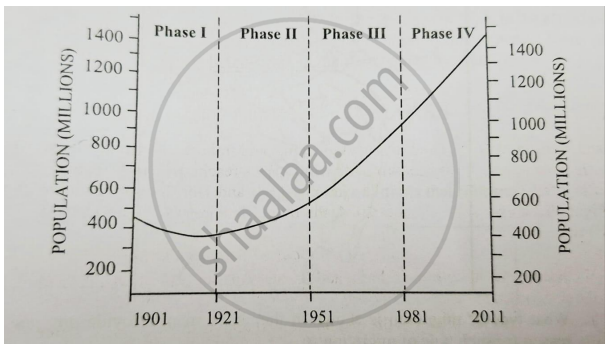
- Phase III indicates a significant change in the population of India. Give any three reasons to account for this change. (3)
- Why is the year 1921 called a year of demographic divide? Give any two reasons for your answer. (2)
- Push factors are important indicators of Population growth in a given area. Explain how these factors have led to change in density of population in the plains of Rajasthan. (2)
Chapter:
India’s breadbasket Punjab has been facing serious challenge of waterlogging due to its extensive canal irrigation system particularly in the southwestern district. This has resulted in a decline of agricultural production and land value.
- How do you think Punjab can balance its agricultural prosperity in spite of this pressing problem which threatens the fertility of land and sustainability of water resources? (3)
- Why is Punjab known as the ‘breadbasket of India’? (4)
Chapter:
Other Solutions
Submit Question Paper
Help us maintain new question papers on Shaalaa.com, so we can continue to help studentsonly jpg, png and pdf files
CISCE previous year question papers Class 12 Geography with solutions 2025 - 2026
Previous year Question paper for CISCE Class 12 -2026 is solved by experts. Solved question papers gives you the chance to check yourself after your mock test.
By referring the question paper Solutions for Geography, you can scale your preparation level and work on your weak areas. It will also help the candidates in developing the time-management skills. Practice makes perfect, and there is no better way to practice than to attempt previous year question paper solutions of CISCE Class 12.
How CISCE Class 12 Question Paper solutions Help Students ?
• Question paper solutions for Geography will helps students to prepare for exam.
• Question paper with answer will boost students confidence in exam time and also give you an idea About the important questions and topics to be prepared for the board exam.
• For finding solution of question papers no need to refer so multiple sources like textbook or guides.
