Advertisements
Advertisements
Question
Study the map given in the figure and answer the following questions.
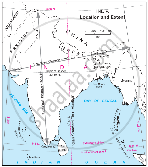
- Calculate the difference between the two longitudinal extremes of mainland India. Is it more than Brazil?
- Which longitude in India is called the Indian Standard Time (IST)?
- What is the difference between this time and the GMT?
- How many local times are there in India?
Long Answer
Advertisements
Solution
- The difference between the two longitudinal extremes of east and west mainland India is about 29°, whereas the difference between the two longitudinal extremes of east and west mainland Brazil is about 39°. No, it is not more than Brazil.
- The 82° 30′ E longitude is called Indian Standard Time (IST).
- The IST time is 5 hours and 30 minutes ahead of the GMT.
- One of the 29 local times (82° 30' E Longitude) is considered IST in India.
shaalaa.com
Is there an error in this question or solution?
APPEARS IN
RELATED QUESTIONS
Match the columns.
| ‘A’ Group | ‘B’ Group |
| (a) Trans-Amazonian | (i) Tourist Place Highway |
| (b) Road Transport | (ii) Railway Station in India |
| (c) Rio de Janeiro | (iii) Golden Quadrilateral |
| (d) Manmad | (iv) Major Highways |
| (v) 40° W. Meridian |
On what basis will you decide how many standard times should be there in a country?
Distinguish between Personal communication and mass communication.
Distinguish between
Print Media and Electronic Media.
Since 1957 All India Radio came to be called ______.
The multi-purpose satellite system for telecommunication is ______ - INSAT.
Answer in a paragraph:
What are the means of transportation and communication called the lifelines of a nation and its economy?
The ______ is the first communication Satellite in INSAT Series.
What are the advantages of a communication network?
Write the full form of STD, ISD, PCO, Internet.
