Advertisements
Advertisements
प्रश्न
Study the map given in the figure and answer the following questions.
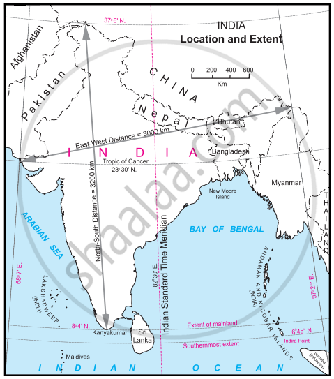
- Calculate the difference between the two longitudinal extremes of mainland India. Is it more than Brazil?
- Which longitude in India is called the Indian Standard Time (IST)?
- What is the difference between this time and the GMT?
- How many local times are there in India?
दीर्घउत्तर
Advertisements
उत्तर
- The difference between the two longitudinal extremes of east and west mainland India is about 29°, whereas the difference between the two longitudinal extremes of east and west mainland Brazil is about 39°. No, it is not more than Brazil.
- The 82° 30′ E longitude is called Indian Standard Time (IST).
- The IST time is 5 hours and 30 minutes ahead of the GMT.
- One of the 29 local times (82° 30' E Longitude) is considered IST in India.
shaalaa.com
क्या इस प्रश्न या उत्तर में कोई त्रुटि है?
APPEARS IN
संबंधित प्रश्न
Which means of communication has expedited the field of communications?
Match the columns.
| ‘A’ Group | ‘B’ Group |
| (a) Trans-Amazonian | (i) Tourist Place Highway |
| (b) Road Transport | (ii) Railway Station in India |
| (c) Rio de Janeiro | (iii) Golden Quadrilateral |
| (d) Manmad | (iv) Major Highways |
| (v) 40° W. Meridian |
The National Remote sensing Centre(NRSC) is located at ______.
What is communication? What are its types?
Postal service and telegraph are some of the ______ communication.
The ______ are the most powerful means of print media.
The multi-purpose satellite system for telecommunication is ______ - INSAT.
Write the full form of STD, ISD, PCO, Internet.
Write a short note on the Internet.
Which longitude in India is considered as Indian Standard Time?
