Advertisements
Advertisements
प्रश्न
Study the map given in the figure and answer the following questions.
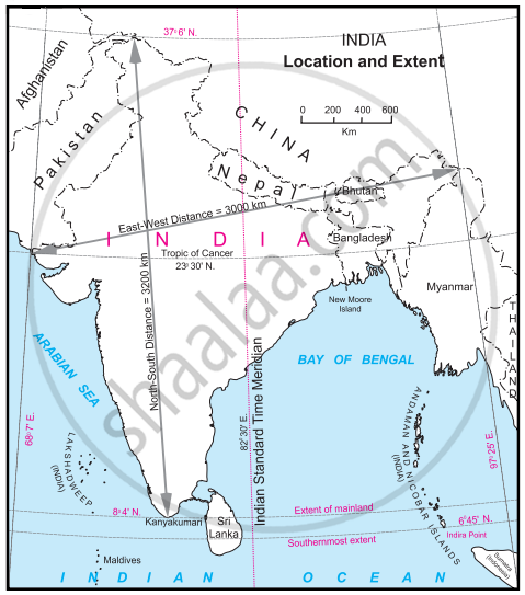
- Calculate the difference between the two longitudinal extremes of mainland India. Is it more than Brazil?
- Which longitude in India is called the Indian Standard Time (IST)?
- What is the difference between this time and the GMT?
- How many local times are there in India?
दीर्घउत्तर
Advertisements
उत्तर
- The difference between the two longitudinal extremes of east and west mainland India is about 29°, whereas the difference between the two longitudinal extremes of east and west mainland Brazil is about 39°. No, it is not more than Brazil.
- The 82° 30′ E longitude is called Indian Standard Time (IST).
- The IST time is 5 hours and 30 minutes ahead of the GMT.
- One of the 29 local times (82° 30' E Longitude) is considered IST in India.
shaalaa.com
या प्रश्नात किंवा उत्तरात काही त्रुटी आहे का?
APPEARS IN
संबंधित प्रश्न
Which means of communication has expedited the field of communications?
Match the following:
| A | B | ||
| 1. | Trans Amazonian route | a. | Tourist spot |
| 2. | Road transportation in India | b. | Railway station in India |
| 3. | Rio de Janerio | c. | Golden quadrilateral highway |
| d. | Important transport route of Brazil |
The National Remote sensing Centre(NRSC) is located at ______.
Distinguish between Personal communication and mass communication.
Explain the importance of satellite communication in India
Since 1957 All India Radio came to be called ______.
The latest means of communication is ______.
Answer in a paragraph:
What are the means of transportation and communication called the lifelines of a nation and its economy?
Indian Space Research organization was established in the year ______.
Write the full form of STD, ISD, PCO, Internet.
