Advertisements
Advertisements
Question
On a Political Map of India, show all the States and Union territories of India along with their Capitals.
Advertisements
Solution
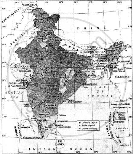
India : Political
APPEARS IN
RELATED QUESTIONS
Match the column.
| A group | B group |
| 1) The southernmost point of India | 1) Gangotri |
| 2) The highlands in eastern Brazil | 2) Andes mountains |
| 3) The origin of Ganga | 3) Guyana Highlands |
| 4) the origin of Amazon | 4) Indira Point |
| 5) Yamunotri | |
| 6) The Great Escarpment |
Fill in the blank:
India is a part of the continent of _______.
Name the island group which lies towards the east of India.
Name the mountain ranges in the eastern part of India forming its boundary with Myanmar.
India is the ______ largest country in Asia.
Why is India called a Sub-continent? How it is separated?
Show the following in the outline map of India with index.
- Thar desert
- Ladakh
- 0-20% urbanization state at the east of India
- Apple producing state at north most of India
- Chennai port
- Kanyakumari-a tourist centre
Identify the following with the help of map reading.
The States through which the Tropic of Cancer passes.
Identify the following with the help of map reading.
The northernmost latitude in degrees.
Which is the popular sport of Brazil ?
