Advertisements
Advertisements
प्रश्न
On a Political Map of India, show all the States and Union territories of India along with their Capitals.
Advertisements
उत्तर
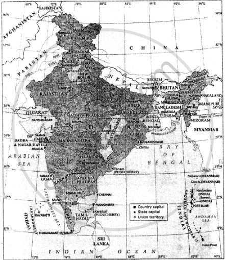
India : Political
APPEARS IN
संबंधित प्रश्न
Read the following graph and answer the questions.
Temperature and Rainfall in Brazil and India
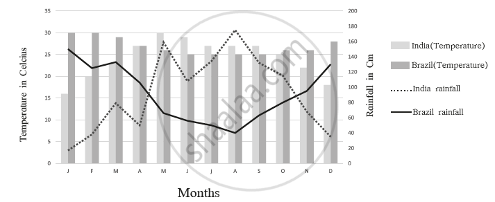
- What is the minimum and maximum temperature of India
- What difference do you find in the rainy period in Brazil and India?
- In which month does Brazil get less rainfall?
- In which month does India get higher rainfall?
- In which month does India get less rainfall?
- In which month does Brazil have a higher temperature?
Is this sentence right or wrong? Rewrite the wrong ones.
The southern part of India is called the Peninsula.
Considering hemisphere, which shape correctly represents the hemisphere in which India lies?
The land in India gets an abundance of sunshine from the ______ sun.
What is the southernmost part of India?
Name the mountain ranges in the eastern part of India forming its boundary with Myanmar.
India is ______ times bigger than Pakistan.
Write the answer in one sentence-
Location of India is in which hemisphere?
Show the following in the outline map of India with index.
- Thar desert
- Ladakh
- 0-20% urbanization state at the east of India
- Apple producing state at north most of India
- Chennai port
- Kanyakumari-a tourist centre
India is located in the ______ hemispheres of the earth.
