Advertisements
Advertisements
Question
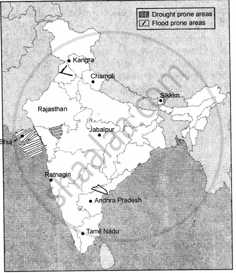
On an outline map of India mark the following
- Earthquake zones with moderate damage risk and high damage risk.
- Any two flood-prone areas
- Any two cyclone zones
- Any two drought-prone areas
Advertisements
Solution
- (a) Earthquake zones with moderate damage risk are : Jabalpur, Ratnagiri.
(b) Earthquake zones with high damage risk are : Chamoli, Sikkim.
(c) Earthquake zones with very high damage risk are: Kangra, Bhuj. - Two floods prone areas are : Rivers of Punjab, River Krishna.
- Two cyclones zone are : Andhra Pradesh and Tamil Nadu.
- Two drought prone areas are : Gujarat and Rajasthan.
APPEARS IN
RELATED QUESTIONS
Fill in the blanks
The ______ of the earth’s plates caused the earthquake in Nepal in April 2015.
Choose the correct answer
In 1986, an accidental explosion at a nuclear plant at ________ in the former USSR caused radiation to spread across Ukraine and other regions, killing over 12,000 people.
State whether the following are true or false
Earthquakes also trigger landslides, avalanches, and tsunamis.
What are the conditions people face during a drought?
Which countries are more adversely affected by disasters? Why?
What is the difference between a hazard and a disaster?
What are biological disasters?
Fill in the blanks
While most disasters happen suddenly like earthquake, nuclear explosion, others like ______ may have a slow beginning and later increase in extent and intensity.
Fill in the blanks
Disasters affect people living in ______ countries more adversely.
Fill in the blank:
Proper planning can help in limiting and _______damages and losses resulting from any disaster-natural or man-made.
