Advertisements
Advertisements
प्रश्न
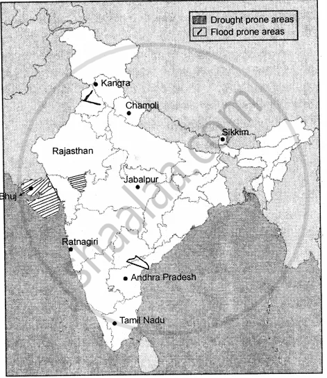
On an outline map of India mark the following
- Earthquake zones with moderate damage risk and high damage risk.
- Any two flood-prone areas
- Any two cyclone zones
- Any two drought-prone areas
नक्शा
Advertisements
उत्तर
- (a) Earthquake zones with moderate damage risk are : Jabalpur, Ratnagiri.
(b) Earthquake zones with high damage risk are : Chamoli, Sikkim.
(c) Earthquake zones with very high damage risk are: Kangra, Bhuj. - Two floods prone areas are : Rivers of Punjab, River Krishna.
- Two cyclones zone are : Andhra Pradesh and Tamil Nadu.
- Two drought prone areas are : Gujarat and Rajasthan.
shaalaa.com
Natural and Manmade Disasters
क्या इस प्रश्न या उत्तर में कोई त्रुटि है?
APPEARS IN
संबंधित प्रश्न
Fill in the blanks
The ______ gas tragedy was caused by the accidental leakage of a highly toxic gas called methyl isocyanate from the Union Carbide factory.
State whether the following are true or false
Earthquakes also trigger landslides, avalanches, and tsunamis.
How is a cyclone caused?
Identify the type of disaster as shown in the picture.
What do you understand by natural disasters?
What is the difference between a hazard and a disaster?
What are an earthquakes effects?
Give an example of the intentional nuclear disaster and unintentional nuclear disaster.
Name two wildlife sanctuaries of Assam.
Fill in the blanks
Heavy rainfall in Assam causes the ______ river and its tributaries to overflow.
