Advertisements
Advertisements
प्रश्न
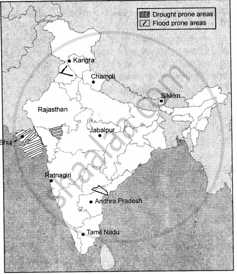
On an outline map of India mark the following
- Earthquake zones with moderate damage risk and high damage risk.
- Any two flood-prone areas
- Any two cyclone zones
- Any two drought-prone areas
Advertisements
उत्तर
- (a) Earthquake zones with moderate damage risk are : Jabalpur, Ratnagiri.
(b) Earthquake zones with high damage risk are : Chamoli, Sikkim.
(c) Earthquake zones with very high damage risk are: Kangra, Bhuj. - Two floods prone areas are : Rivers of Punjab, River Krishna.
- Two cyclones zone are : Andhra Pradesh and Tamil Nadu.
- Two drought prone areas are : Gujarat and Rajasthan.
APPEARS IN
संबंधित प्रश्न
State whether the following are true or false
The attacks carried out on Hiroshima and Nagasaki by the United States during World War II were an example of unintentional nuclear disaster.
How do chemical disasters occur?
What makes Bihar the most flood-prone state among all north Indian states?
Define: Epidemic
Fill in the blanks
______ are mostly caused due to the overflowing of rivers in the monsoon.
Fill in the blanks
______ explosion is the largest oil spill in the history of petroleum industry.
Fill in the blanks
Heavy rainfall in Assam causes the ______ river and its tributaries to overflow.
Fill in the blank:
Proper _________can help in limiting and minimizing damages and losses caused by natural or man-made disasters.
Fill in the blank:
______help in drawing moisture and rainfall to a region.
Fill in the blank:
We should make an effort to know more about the different kinds of ___________ to use in case of fire.
