Advertisements
Advertisements
Question
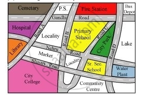
Look at the given map of a city.

Answer the following.
(a) Colour the map as follows: Blue − water plant, red − fire station, orange − library, yellow − schools, green − park, pink − college, purple − hospital, brown − cemetery.
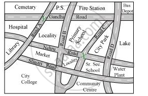
(b) Mark a green ‘X’ at the intersection of Road ‘C’ and Nehru Road, Green ‘Y’ at the intersection of Gandhi Road and Road A.
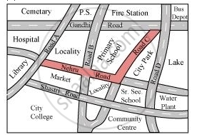
(c) In red, draw a short street route from library to the bus depot.
(d) Which is further east, the city park or the market?
(e) Which is further south, the Primary School or the Sr. Secondary School?
Advertisements
Solution
1)The given map coloured in the required way is as follows.
2) The marks can be put at the given points as follows.
3) The shortest route from the library to bus depot is represented by red colour.
4) Between the Market and the City Park, the City Park is further east.
5) Between the Primary School and the Sr. Secondary School, the Sr. Secondary School is further south.
RELATED QUESTIONS

(i) How many paths are there to reach temple from bus stop?
(ii) Which is the longest path and shortest path?
(iii) Specify the two places on the route from market to school?
(iv) ___________ is the places found between temple and mosque
(a) Bank
(b) textle
(c) Library
Draw a map of your school playground. Mark all necessary places like 2 library, Playground, Medical Room, Classrooms, Assembly area, etc.
Refer to the given map to answer the following questions.
Name the schools shown in the picture.
Refer to the given map to answer the following questions.
Which park is nearest to the dispensary?
Refer to the given map to answer the following questions.
How many parks have been represented in the map?
The side of a square board is 50 cm. A student has to draw its image in her notebook. If the drawing of the square board in the notebook has perimeter of 40 cm, then by which scale the figure has been drawn?
The distance between school and house of a girl is given by 5 cm in a picture, using the scale 1 cm : 5 km. Find the actual distance between the two places?
Find the scale.
Actual size 45 feet
Drawing size 5 inches
Look at the map given below![]() Houses
Houses
Now, answer the following questions.
On which road is the Police Station situated?
Look at the map given below![]() Houses
Houses
Now, answer the following questions.
Which sector has maximum number of houses?
