Advertisements
Advertisements
प्रश्न
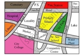
Look at the given map of a city.

Answer the following.
(a) Colour the map as follows: Blue − water plant, red − fire station, orange − library, yellow − schools, green − park, pink − college, purple − hospital, brown − cemetery.
(b) Mark a green ‘X’ at the intersection of Road ‘C’ and Nehru Road, Green ‘Y’ at the intersection of Gandhi Road and Road A.
(c) In red, draw a short street route from library to the bus depot.
(d) Which is further east, the city park or the market?
(e) Which is further south, the Primary School or the Sr. Secondary School?
Advertisements
उत्तर
1)The given map coloured in the required way is as follows.
2) The marks can be put at the given points as follows.
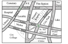
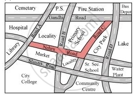
3) The shortest route from the library to bus depot is represented by red colour.
4) Between the Market and the City Park, the City Park is further east.
5) Between the Primary School and the Sr. Secondary School, the Sr. Secondary School is further south.
संबंधित प्रश्न
All the classrooms in Ashi s school look like this. Look carefully and answer.

- Which of these is exactly opposite to the blackboard?
Almirah, windows, notice board, display board
The following is the map of a town. Based on it answer question.

According to the map, the number of schools in the town is ______.
The model of a ship shown is of height 3.5 cm. The actual height of the ship is 210 cm if the scale chosen is 1 : 60.

Refer to the given map to answer the following questions.
- What is the built-up area of Govt. Model School I?
- Name the schools shown in the picture.
- Which park is nearest to the dispensary?
- To which block does the main market belong?
- How many parks have been represented in the map?
Refer to the given map to answer the following questions.
Name the schools shown in the picture.
Look at the map given below.
 Houses
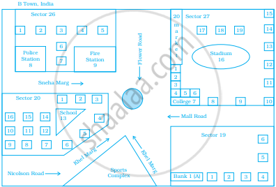
Now, answer the following questions.
- Name the roads that meet at round about.
- What is the address of the stadium?
- On which road is the Police Station situated?
- If Ritika stays adjacent to bank and you have to send her a card, what address will you write?
- Which sector has maximum number of houses?
- In which sector is Fire Station located?
- In the map, how many sectors have been shown?
The actual length of a painting was 2 m. What is its length in the photograph if the scale used is 1 mm : 20 cm.
Find the scale.
Actual size 12 m
Drawing size 3 cm
In a town, an ice cream parlour has displayed an ice cream sculpture of height 360 cm. The parlour claims that these ice creams and the sculpture are in the scale 1 : 30. What is the height of the ice creams served?
Look at the map given below![]() Houses
Houses
Now, answer the following questions.
Which sector has maximum number of houses?
