Advertisements
Advertisements
प्रश्न
Refer to the given map to answer the following questions.
- What is the built-up area of Govt. Model School I?
- Name the schools shown in the picture.
- Which park is nearest to the dispensary?
- To which block does the main market belong?
- How many parks have been represented in the map?
Advertisements
उत्तर
- The built-up area of Govt. Model School I is equal to 2.1 acre.
- Two schools shown in the picture, Govt. Model School I and II.
- Part A is nearest to the dispensary.
- The main market belongs to block A.
- 6 parks have been represented in the map.
APPEARS IN
संबंधित प्रश्न
Prepare a plan to buy the necessary books for the school library. Arranging the books in order
All the classrooms in Ashi s school look like this. Look carefully and answer.

- Can a child sitting in III-A see the playground?
In a blueprint of a room, an architect has shown the height of the room as 33 cm. If the actual height of the room is 330 cm, then the scale used by her is ______.
The following is the map of a town. Based on it answer question.
The number of hospitals in the town is ______.
If actual distance between two places A and B is 110 km and it is represented on a map by 25 mm. Then the scale used is ______.
Refer to the given map to answer the following questions.
Which park is nearest to the dispensary?
Look at the map given below. Answer the following questions.
- Which two hospitals are opposite to each other?
- A person residing at Niti Bagh has to go to Chirag Delhi after dropping her daughter at Asiad Tower. Mention the important landmarks he will pass alongwith the roads taken.
- Name of which road is similar to the name of some month.

Look at the map given below.
 Houses
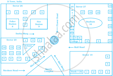
Now, answer the following questions.
- Name the roads that meet at round about.
- What is the address of the stadium?
- On which road is the Police Station situated?
- If Ritika stays adjacent to bank and you have to send her a card, what address will you write?
- Which sector has maximum number of houses?
- In which sector is Fire Station located?
- In the map, how many sectors have been shown?
The distance between school and house of a girl is given by 5 cm in a picture, using the scale 1 cm : 5 km. Find the actual distance between the two places?
Use a ruler to measure the distance in cm between the places joined by dotted lines. If the map has been drawn using the scale 1 cm : 10 km, find the actual distances between house and school.

