Advertisements
Advertisements
प्रश्न
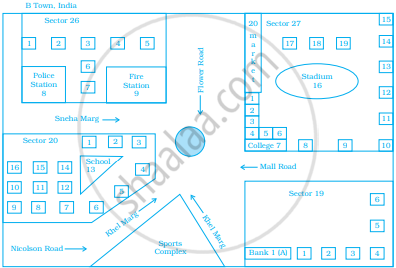
Look at the map given below.
 Houses
Now, answer the following questions.
- Name the roads that meet at round about.
- What is the address of the stadium?
- On which road is the Police Station situated?
- If Ritika stays adjacent to bank and you have to send her a card, what address will you write?
- Which sector has maximum number of houses?
- In which sector is Fire Station located?
- In the map, how many sectors have been shown?
Advertisements
उत्तर
Carefully see the map.
a. Flower road, Khel marg, Mall road and Sneha marg road meet at round.
b. The address of the stadium is given below:
Sector 27.
B Town, India
c. The police station is situated on Sneha marg.
d. Sneha’s address is given below:
H.N-1Nr. Bank 1 (A)
Sector 19, B town, India
e. Sector 27 has maximum number of houses.
f. Fire station is located in sector 26.
g. In the map, four sectors have been shown.
APPEARS IN
संबंधित प्रश्न
All the classrooms in Ashi s school look like this. Look carefully and answer.

- Which of these is exactly opposite to the blackboard?
Almirah, windows, notice board, display board
The following is the map of a town. Based on it answer question.

According to the map, the number of schools in the town is ______.
If actual distance between two places A and B is 110 km and it is represented on a map by 25 mm. Then the scale used is ______.
If a length of 100 m is represented on a map by 1 cm, then the actual distance corresponding to 2 cm is 200 m.
Refer to the given map to answer the following questions.
To which block does the main market belong?
Refer to the given map to answer the following questions.
How many parks have been represented in the map?
Look at the map given below. Answer the following questions.
- Which two hospitals are opposite to each other?
- A person residing at Niti Bagh has to go to Chirag Delhi after dropping her daughter at Asiad Tower. Mention the important landmarks he will pass alongwith the roads taken.
- Name of which road is similar to the name of some month.

A photographer uses a computer program to enlarge a photograph. What is the scale according to which the width has enlarged?

Use a ruler to measure the distance in cm between the places joined by dotted lines. If the map has been drawn using the scale 1 cm : 10 km, find the actual distances between college and complex.

Use a ruler to measure the distance in cm between the places joined by dotted lines. If the map has been drawn using the scale 1 cm : 10 km, find the actual distances between house and school.

