Advertisements
Advertisements
Question
Draw the convectional signs and symbols to given points
a) Bridge
b) Canal
c) Dam
d) Temple
e) Forest
f) Railway Station
Advertisements
Solution
| a) | Bridge | 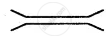 |
| b) | Canal |  |
| c) | Dam |  |
| d) | Temple |  |
| e) | Forest |  |
| f) | Railway Station |  |
APPEARS IN
RELATED QUESTIONS
Choose the correct answer
This is not one of the five basic elements of a map
Make a clay globe in your art class and mark the major latitudes and longitudes using the following colours. Blue, green, and brown.
Fill in the blank
Mountains, hills, rivers, etc. are ______features shown on a map
Your friend has invited you to his house. He has drawn a rough sketch on a paper showing the direction to his house for you.
How does the sketch help you? What quality of your friend is shown through in this gesture?
______ in a map which explains the different colours and symbols used in it.
Choose the odd one
The ______ of a map describes the information given in the map.
The ______ have standardized a set of conventional signs and symbols.
map 1 cm is equal to ______ km on the grand.
The features of ______ colour in Map is Forest.
