Advertisements
Advertisements
प्रश्न
Draw the convectional signs and symbols to given points
a) Bridge
b) Canal
c) Dam
d) Temple
e) Forest
f) Railway Station
Advertisements
उत्तर
| a) | Bridge | 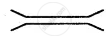 |
| b) | Canal |  |
| c) | Dam |  |
| d) | Temple |  |
| e) | Forest |  |
| f) | Railway Station |  |
APPEARS IN
संबंधित प्रश्न
Choose the correct answer
The numerator of a representative fraction is always
Answer the following question in brief.
What is a legend or key?
Answer the following question in one or two paragraphs.
What are the five different elements of a map? Explain them briefly.
Find latitudes and longitudes:
You will need an atlas. Turn to the index pages and find the latitudes and longitudes of these Indian cities.
| Place | Latitude | Longitude |
| i. Delhi | __________ | _________ |
| ii. Kolkata | _________ | _________ |
| iii. Mumbai | _________ | _________ |
| iv. Chennai | _________ | _________ |
| v. Bengaluru | _________ | _________ |
| vi. Srinagar | _________ | _________ |
What are cardinal directions?
Write a note on conventional signs and symbols.
In general, maps are drawn with ______ orientation.
The features of ______ colour in Map is Waterbodies.
The features of ______ colour in Map is Railway line.
The features of ______ colour in Map is Settlements, Road.
