Advertisements
Advertisements
Question
Collect information about the ‘Silk Route’. Also find out the new developments, which are improving communication routes in the regions of high altitude.
Advertisements
Solution
The Silk Road or Silk Route refers to a historical network of interlinking trade routes across the Afro-Eurasian landmass that connected East, South. and Western Asia with the Mediterranean and European world, as well as parts of North and East Africa.
The land routes were supplemented by sea routes, which extended from the Red Sea to coastal India, China, and South-East Asia.
Extending 4,000 miles (6,500 km), the Silk Road gets its name from the lucrative Chinese silk trade along with it. which began during the Han Dynasty (206 BCE – 220 CE). The central Asian sections of the trade routes were expanded around 114 BCE by the Han dynasty largely through the missions and explorations of Zhang Qian, but earlier trade routes across the continents already existed.
In the late Middle Ages. transcontinental trade over the land routes of the Silk Road declined as sea trade increased. In recent years, both the maritime and overland Silk Routes are again being used, often closely following the ancient routes.
APPEARS IN
RELATED QUESTIONS
Read the following graph and answer the questions.
Temperature and Rainfall in Brazil and India
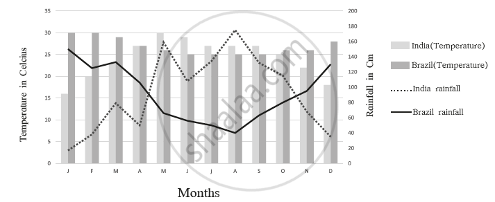
- What is the minimum and maximum temperature of India
- What difference do you find in the rainy period in Brazil and India?
- In which month does Brazil get less rainfall?
- In which month does India get higher rainfall?
- In which month does India get less rainfall?
- In which month does Brazil have a higher temperature?
The sun rises two hours earlier in Arunachal Pradesh as compared to Gujarat in the west but the watches show the same time. How does this happen?
The central location of India at the head of the Indian Ocean is considered of great significance. Why?
Considering hemisphere, which shape correctly represents the hemisphere in which India lies?
Name the countries that form the India subcontinent.
Fill in the blank:
The __________ extend from Punjab in the west to the Brahmaputra Valley in the east.
On a Political Map of India, show all the States and Union territories of India along with their Capitals.
On an outline map of India, show the important physical features.
How much distance has been reduced between India and Europe by the construction of the Suez Canal?
The ______ latitude passes through the middle of the country.
