ISC (Commerce)
ISC (Arts)
ISC (Science)
Academic Year: 2017-2018
Date: मार्च 2018
Advertisements
- Answer Section A and B from Part I which are compulsory.
- Answer any four questions from Part II.
Give two reasons to explain why India is considered to be a subcontinent.
Chapter: [1] Locational Setting of India
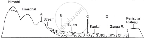
The figure below represents a topographic section from the Himalayas to the Peninsular region. Identify any two of the features marked A, B, C and D.
Chapter:
With reference to the Godavari River, name the following:
The State where it originates.
Chapter:
With reference to the Godavari River, name the following:
The State where it forms its delta.
Chapter:
Answer the following question.
Write any two objectives of urban forestry.
Chapter:
State two reasons to explain why irrigation is necessary in India.
Chapter:
Briefly explain any two problems caused by the Green Revolution with respect to Indian agriculture.
Chapter: [14] Agriculture
State any two important aspects of environmental management.
Chapter:
Mention two ways in which hydroelectric power is better than nuclear power.
Chapter: [16] Minerals and Power Resources
Give two advantages of transportation by roadways.
Chapter:
Mention two major challenges faced by the tourism industry in India today.
Chapter: [19] Tourism Industry
On the outline map of India provided :
(a) Mark and name the southernmost point of the Indian mainland.
(b) Mark and name the highest peak of the Trans Himalayas.
(c) Mark and name the Vindhyas.
(d) Mark and name the Chota Nagpur Plateau.
(e) Print HP over an area experiencing high pressure during the winter season.
(f) Trace the course and label river Kaveri.
(g) With the help of an arrow show the direction and name the wind that brings rainfall over the Gangetic Plains during the monsoon season. (h) Shade and name the State with the highest rural population.
(i) Mark and name the State which has the highest sex ratio.
(j) Locate and label the southernmost port city on the west coast.
Note: All the map work, including legend (Index), should be done on the map sheet only.
Chapter:
Give three differences between the Western and the Eastern Himalayas.
Chapter:
Explain the following:
The Himalayan rivers are typical examples of antecedent drainage.
Chapter:
Explain the Jaisalmer receives very less rainfall annually.
Chapter:
Study the climatic data provided in the table below for a city A in India and answer the questions that follow:
| City | T/R | J | F | M | A | M | J | J | A | S | O | N | D |
| A | T | -8 | -3 | 2 | 7 | 15 | 18 | 17 | 12 | 10 | 5 | 0 | -7 |
| R | 10 | 8 | 8 | 5 | 5 | 5 | 13 | 13 | 8 | 5 | 0 | 5 |
T = Mean monthly temperature in degree Celsius (°C).
R = Average monthly rainfall in millimeters (mm).
- What is the cause of low rainfall in station A?
- Calculate the range of temperature of this station.
Chapter:
State how rainfall and temperature influence the vegetation type in India.
Chapter:
Why are tropical evergreen forests not very important economically?
Chapter:
Advertisements
Why is the dependency ratio higher in rural areas than in urban areas? State two reasons.
Chapter:
Distinguish between metropolis and megalopolis.
Chapter:
With reference to the linear rural settlement pattern, answer the following:
How does this pattern develop?
Chapter: [10] Rural Settlements
With reference to the linear rural settlement pattern, answer the following:
Name any two areas where this pattern is found in India.
Chapter: [10] Rural Settlements
What is India’s density of population as per the 2011 census?
Chapter:
The graph below shows the percentage decadal growth rate in India for a period from 1971 to 2011.

- What is the unique characteristic of growth during this period?
- Explain the reason causing this uniqueness.
Chapter:
Mention any two drawbacks of land use patterns in India.
Chapter:
Suggest measures to improve the land-use in India.
Chapter:
Suggest two farming practices which will help to reduce the extent of fallow land?
Chapter:
Mention two reasons why the modern methods of irrigation are preferred over traditional methods of irrigation, in India.
Chapter:
What is the intensity of cropping?
Chapter: [14] Agriculture
Explain why there is a variation of cropping intensity in Punjab.
Chapter: [14] Agriculture
Name the largest cotton-producing state in India.
Chapter:
What are the geographical conditions required for the growth of cotton?
Chapter:
What are the three advantages that Japan has over India with respect to marine fishing?
Chapter:
Advertisements
Name the largest producing state of the following mineral and also give one use of the mineral:
Manganese
Chapter: [16] Minerals and Power Resources
Name the largest producing state of the following mineral and also give one use of the mineral:
Mica
Chapter: [16] Minerals and Power Resources
With reference to the Jawaharlal Nehru Port, state the following:
Its hinterland
Chapter:
With reference to the Jawaharlal Nehru Port, state the following:
Two items of export
Chapter:
With reference to the Jawaharlal Nehru Port, state the following:
Two items of import
Chapter:
Name the city which has the oldest artificial harbor on the east coast of India.
Chapter: [17] Transport and Communication
State two geographical problems faced by this harbor.
Chapter:
State any two ways in which cinema can be considered as powerful means of mass communication.
Chapter:
Mention any three factors that determine the location of an industry.
Chapter:
Identify one industrial cluster from Northern India. State two reasons for its growth.
Chapter:
Explain the following:
Weight losing raw material.
Chapter: [18] Industries
Explain the following:
Integrated steel plant.
Chapter: [18] Industries
State any two negative impacts of tourism on the environment.
Chapter: [19] Tourism Industry
Answer the following question:
What is meant by development? What is the geographer’s perspective on development?
Chapter:
Apart from the Central Level Planning, what are the other levels in the multilevel planning?
Chapter:
With reference to Haldia Port, answer the following question:
Location of the port.
Chapter:
With reference to mining in Chhattisgarh, name the following:
The largest coalfield.
Chapter:
With reference to mining in Chhattisgarh, name the following:
The largest iron-ore mine.
Chapter:
With reference to mining in Chhattisgarh, name the following:
A bauxite mining centre.
Chapter:
Other Solutions
Submit Question Paper
Help us maintain new question papers on Shaalaa.com, so we can continue to help studentsonly jpg, png and pdf files
CISCE previous year question papers Class 12 Geography with solutions 2017 - 2018
Previous year Question paper for CISCE Class 12 -2018 is solved by experts. Solved question papers gives you the chance to check yourself after your mock test.
By referring the question paper Solutions for Geography, you can scale your preparation level and work on your weak areas. It will also help the candidates in developing the time-management skills. Practice makes perfect, and there is no better way to practice than to attempt previous year question paper solutions of CISCE Class 12.
How CISCE Class 12 Question Paper solutions Help Students ?
• Question paper solutions for Geography will helps students to prepare for exam.
• Question paper with answer will boost students confidence in exam time and also give you an idea About the important questions and topics to be prepared for the board exam.
• For finding solution of question papers no need to refer so multiple sources like textbook or guides.
