Advertisements
Advertisements
Question
What are the elements of maps? Write about it?
Advertisements
Solution
Elements of maps:
- Maps provide us with a lot of information and one must know how to read and interpret them.
- Every map is provided with certain features that act as an aid to study the information presented in it.
- The basic essential elements of a map are title, direction, scale and legend (or) key of symbol.
- Title:
Every map has a title that describes the information given in the map. For example, a map with the title India Rivers shows Rivers of India. - Direction:
- In general maps are drawn with north orientation it helps us to find other direction on the map like East, West and South. In addition to the North notation, latitudes and longitudes were depicted in the margins.
- The North is notified by letter ‘N’ with an arrow mark.

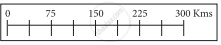
- Scale:
- The scale of a map is the ratio between the distance on the map between two points and actual distance between the two places on the ground.
- The scales can be represented as 1cm = 10km.
- It means 1 cm on the map is equal to 10 km on the ground. It helps to find the distance on the map between two points.
- Legend:
- A legend or key of a map explain the symbols that are used on it to represent various physical and cultural features.
- The common signs and symbols are internationally accepted and used in maps are called conventional signs and symbols.
- Every map has a legend or a key which explains the different colours and symbols used in it.
- They are depicted by using certain colours, symbols or letters.
APPEARS IN
RELATED QUESTIONS
Answer the following question in brief.
What is a legend or key?
Answer the following question in one or two paragraphs.
Explain the functions of the north line and legend on a map.
Answer the following question in one or two paragraphs.
Why is the key or legend an important element of a map?
Write True or False. Correct the false statement.
In permanent settlements, houses are built for a short period of time.
Look at the symbols given here and answer the following question.
How do the features shown by these two symbols differ?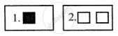
Your friend has invited you to his house. He has drawn a rough sketch on a paper showing the direction to his house for you.
How does the sketch help you? What quality of your friend is shown through in this gesture?
______ in a map which explains the different colours and symbols used in it.
What are cardinal directions?
A sign is a widely used ______ or a ______ pattern.
Write a note on conventional signs and symbols.
