Advertisements
Advertisements
Question
Answer the following question in one or two paragraphs.
Explain the functions of the north line and legend on a map.
Advertisements
Solution
The direction on a map is measured with the help of the north line.
All maps have a key or a legend that explains the colours, signs, and symbols used in them.
The equator (0° latitude) divides the earth into the hemispheres — the northern and the southern hemispheres. All lines of latitude are measured from the equator.
APPEARS IN
RELATED QUESTIONS
Answer the following question in brief.
What are the latitudinal and longitudinal extents of India? Use your atlas to find the answer.
Answer the following question in one or two paragraphs.
Why is the key or legend an important element of a map?
Write True or False. Correct the false statement.
Settlements can either be temporary or permanent.
Look at the symbols given here and answer the following question.
What does symbols 1 and 2 show?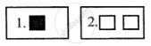
Look at the symbols given here and answer the following question.
How do the features shown by these two symbols differ?
______ in a map which explains the different colours and symbols used in it.
The ______ of a map describes the information given in the map.
Write a note on conventional signs and symbols.
What are the colours used in the maps?
The features of ______ colour in Map is Forest.
