Advertisements
Advertisements
Question
Observe the given map and answer the questions based on it:
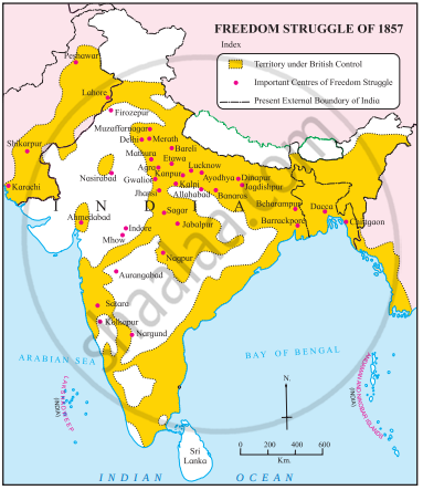
- To which topic is this map related?
- Name any one centre of the independence struggle of 1857 in present Bangladesh.
- Name any one centre of the independence struggle of 1857 in present Pakistan.
- Name any one place of the independence struggle of 1857 in present Maharashtra.
- Name the Indian island located in the Arabian Sea.
Advertisements
Solution
- The map is related to the topic of the Indian Freedom Struggle, specifically concerning the revolt of 1857, which is also known as the First War of Indian Independence.
- A centre of the independence struggle of 1857 in present-day Bangladesh, as marked on the map, is Chittagaon and Dacca.
- Peshawar, Lahore, Karachi, and Shikarpur are indicated on the map as the centers of the independence struggle of 1857 in present-day Pakistan.
- A place of independence struggle of 1857 in present Maharashtra, as seen on the map, is Nagpur, Satara, Kolhapur.
- The Indian island located in the Arabian Sea as per the map is Lakshadweep.
APPEARS IN
RELATED QUESTIONS
Fill in the blanks:
Dalhousie annexed the states of __________ and _________ on the basis of the Doctrine of Lapse.
State whether the following statement is True or false:
The British supported Sati.
What were the causes for the Great revolt of 1857?
The first sign of unrest appeared at ______.
The Revolt of 1857 began from ______.
The ______ was an important episode in the rebellion of 1857.
By the beginning of June 1857 except ______ and ______ British Rule in North India had disappeared because of the mutineers.
Describe the Course of the 1857 Revolt.
Observe the following map and answer the questions based on it:
- Which of the following places on the given map is not present in India?
- Which places in Maharashtra are on the given map?
- Which places in Bangladesh are on the given map?
- Considering the given map, which seas are shown on the map?
- Considering the present map, which of the following states did not witness the uprising of 1857?
Imagine you were present when the rulers of Indian states met at a common place before the Uprising of 1857. Each ruler voiced his grievance against the British. Make a list of the grievances of each of the rulers.
