Advertisements
Advertisements
प्रश्न
Observe the given map and answer the questions based on it:
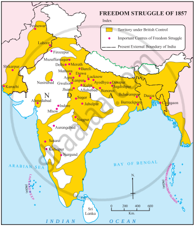
- To which topic is this map related?
- Name any one centre of the independence struggle of 1857 in present Bangladesh.
- Name any one centre of the independence struggle of 1857 in present Pakistan.
- Name any one place of the independence struggle of 1857 in present Maharashtra.
- Name the Indian island located in the Arabian Sea.
संक्षेप में उत्तर
Advertisements
उत्तर
- The map is related to the topic of the Indian Freedom Struggle, specifically concerning the revolt of 1857, which is also known as the First War of Indian Independence.
- A centre of the independence struggle of 1857 in present-day Bangladesh, as marked on the map, is Chittagaon and Dacca.
- Peshawar, Lahore, Karachi, and Shikarpur are indicated on the map as the centers of the independence struggle of 1857 in present-day Pakistan.
- A place of independence struggle of 1857 in present Maharashtra, as seen on the map, is Nagpur, Satara, Kolhapur.
- The Indian island located in the Arabian Sea as per the map is Lakshadweep.
shaalaa.com
क्या इस प्रश्न या उत्तर में कोई त्रुटि है?
APPEARS IN
संबंधित प्रश्न
State whether the following statement is True or false:
The Revolt of 1857 did not involve the masses.
- Dudu Mian laid emphasis on the egalitarian nature of Islam and declared that “Land belongs to God”.
- According to the Doctrine of Lapse, new territories under the corrupt Indian rulers were to be annexed.
- The British officials after the suppression of the 1857 Revolt were given the power to judge and take the lives of Indians without due process of law.
- One of the causes of the failure of the Revolt of 1857 was many of the Indian princes and zamindars remained loyal to the British.
After the 1857 revolt, the British captured Bahadur Shah and transported him to ______.
Who was Tantia Tope?
In 1858, the Royal Durbar was held at ______.
The Kingdom of Jhansi was annexed under ______.
By the beginning of June 1857 except ______ and ______ British Rule in North India had disappeared because of the mutineers.
Answer all the questions under the caption
Great Rebellion of 1857
- What was the biggest challenge witnessed by the British in 1857?
- What was witnessed by both sides during the revolt?
- What were the causes of the revolt?
- What was the people’s opinion on the new regulations of the British?
Narrate the fall of Panchalamkurchi.
Explain the causes of the Freedom struggle of 1857.
