Advertisements
Advertisements
Question
Observe the given figure and write the answers.
 |
- Which region gets more than 4000 mm of rainfall?
- Identify the regions with maximum and minimum temperatures?
- In which direction is the temperature increasing?
- Identify the direction of the winds shown. What are they known as?
- Which winds are responsible for the rainfall in India ?
- Some part of Rajasthan is under desert? What could be the reason for it?
- Draw the main parallel of latitude passing through India which affects its climate.
- In which part of Peninsular India are semi-arid climatic conditions found and why?
Advertisements
Solution
- Western Ghats, Western Coasts of India and the northeastern region comprising Mawsynram, Cherrapunji and parts of Assam and Arunachal Pradesh get more than 4000 mm of rainfall.
- The central and northwestern parts of the Peninsular Plateau and the islands have high temperatures. Hilly regions of north, northeast and south India have low temperatures.
- Temperature is increasing in the NorthWestern, Eastern and Southern directions.
- The winds shown are blowing from the south west to north east direction. These winds are called Southwest Monsoon Winds.
- South-West Monsoon Winds are responsible for rainfall in India.
- The South West Monsoon Winds blow parallel to the Aravallis. As these moisture-laden winds are not obstructed by the Aravallis, it rains less here. Hence, Rajasthan is under desert.

-
- The part of peninsular India which has semi-arid climatic conditions are central part of Peninsula Plateau comprising parts of Central Maharashtra, Western Andhra Pradesh, Eastern Karnataka and Western Tamil Nadu. These regions lie on the leeward side of the Western Ghats and Eastern Ghats. It rains less here and a rain shadow region is formed.
- Some parts of Gujarat and Rajasthan are also semi-arid, as the Aravallis lie parallel and do not obstruct the South-west Monsoon winds.
APPEARS IN
RELATED QUESTIONS
The average annual temperature in India is generally high.
Chennai enjoys ______ climate.
Match the Column I with Column II.
| Column I | Column II | |
| A. | Tropical evergreen forest | Sandal wood |
| B. | Tropical Deciduous forest | Oak, silver fir |
| C. | Alpine forest | Black buck |
| D. | Tidal forest | Casuarina |
| E. | Coastal forest | Mahogany |
| F. | State animal of Andhra Pradesh, Pujab and Haryana | Mangrove trees |
The Himalayas act not only as physical barrier but also as ______.
Since the northern plains are far away from the influence of the seas, they have ______.
Where is monsoon experienced mainly?
Find out which songs, dances, festivals and special food preparations are associated with certain seasons in your region. Do they have some commonality with other regions of India?
Observe the following graph and answer the questions given below:
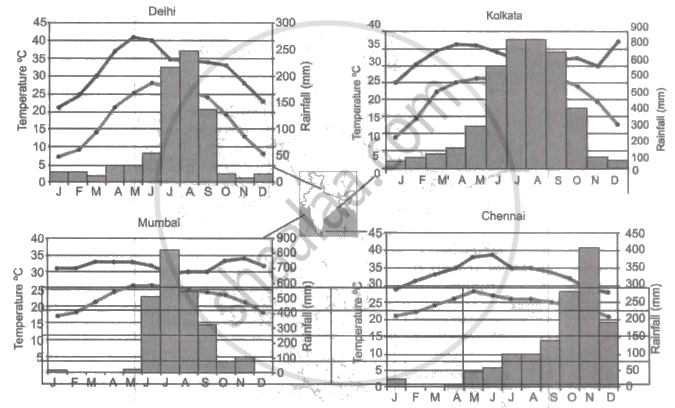
Note: In the graphs, the dark line represents the max. temperature and the lighter line represents min. temperature. The bars represent the amount of rainfall every month in each city.
- Where in the four cities is the rainfall heaviest?
- Which city has the most rainfall throughout the year?
- Which city experiences the highest temperature?
- Calculate the average range of minimum and maximum temperature for all four cities.
- What do the temperature curves in Delhi indicate?
- What is the condition of Mumbai during monsoons?
Why the houses in Rajasthan have thick walls and flat roofs?
Why is it that the houses in the Tarai region and in Goa and Mangalore have sloping roofs?
