Advertisements
Advertisements
Question
A photographer uses a computer program to enlarge a photograph. What is the scale according to which the width has enlarged?

Advertisements
Solution
By the given graph, we have width before editing = 2 units
Width after editing = 4 units
We know that,
Scale = `"Size before editing"/"Size after editing"`
∴ Scale = `2/4 = 1/2 = 1 : 2`
Hence, scale used to enlarge the photograph is 1 : 2.
APPEARS IN
RELATED QUESTIONS
All the classrooms in Ashi s school look like this. Look carefully and answer.

- Which of these is exactly opposite to the blackboard?
Almirah, windows, notice board, display board
The following is the map of a town. Based on it answer question.
The number of hospitals in the town is ______.
The following is the map of a town. Based on it answer question.
The ratio of the number of general stores and that of the ground is ______.
The following is the map of a town. Based on it answer question.
According to the map, the number of schools in the town is ______.
Draw a map of your school playground. Mark all necessary places like 2 library, Playground, Medical Room, Classrooms, Assembly area, etc.
Refer to the given map to answer the following questions.
- What is the built-up area of Govt. Model School I?
- Name the schools shown in the picture.
- Which park is nearest to the dispensary?
- To which block does the main market belong?
- How many parks have been represented in the map?
Look at the map given below. Answer the following questions.
- Which two hospitals are opposite to each other?
- A person residing at Niti Bagh has to go to Chirag Delhi after dropping her daughter at Asiad Tower. Mention the important landmarks he will pass alongwith the roads taken.
- Name of which road is similar to the name of some month.

Look at the map given below.
 Houses
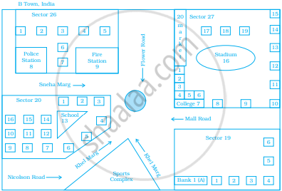
Now, answer the following questions.
- Name the roads that meet at round about.
- What is the address of the stadium?
- On which road is the Police Station situated?
- If Ritika stays adjacent to bank and you have to send her a card, what address will you write?
- Which sector has maximum number of houses?
- In which sector is Fire Station located?
- In the map, how many sectors have been shown?
The actual length of a painting was 2 m. What is its length in the photograph if the scale used is 1 mm : 20 cm.
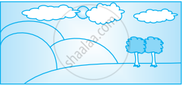
Find the scale.
Actual size 12 m
Drawing size 3 cm
