Please select a subject first
Advertisements
Advertisements
What are fiords? How are they formed?
Concept: undefined >> undefined
Briefly describe the location of Europe in relation to the other continents. What special advantage has Europe enjoyed due to its location?
Concept: undefined >> undefined
Advertisements
What is biogas? How is it useful to us?
Concept: undefined >> undefined
Write a short note on the capital city of Russia.
Concept: undefined >> undefined
Describe the Northern Mountains of Europe.
Concept: undefined >> undefined
Write a note on the Central European Plains.
Concept: undefined >> undefined
Explain briefly geothermal energy.
Concept: undefined >> undefined
Describe briefly the major young fold mountains of Europe.
Concept: undefined >> undefined
What is the significance of the many big and small rivers of Europe?
Concept: undefined >> undefined
Large – scale hydroelectric projects have an impact on the environment. Search the Internet to find out how these projects affect the flora and fauna, and people’s lives in the area.
Concept: undefined >> undefined
On the outline map of India given here, mark and name any five hydroelectric projects in India.
Concept: undefined >> undefined
Where does your water come from?
Each city has a different source for its water supply like reservoirs, rivers, or wells. Find out where your town or city gets its supply of water from.
Concept: undefined >> undefined
In your atlas, locate the major and minor rivers flowing through Europe. Note the names of important cities/towns that have developed on the banks of these rivers. Then tabulate your observations in your notebook using the headings given here :
- Name of the river
- Countries through which it flows
- Important town/cities situated on its banks.
Concept: undefined >> undefined
The Scandinavian coutnries are generally considered to have a separate cultural identity. Form groups in your class and search the Internet to gather information on these countries and then hold a discussion under the following points.
- employment
- education
- law and order
- care for the aged
Concept: undefined >> undefined
On the outline map of Europe, use different colours to mark and label the following:
- Oceans—Arctic, Atlantic
- Seas—Mediterranean, Baltic, North Sea
- Straits—Dover, Gibraltar
- Plateau—Central Massif, Meseta
- Mountains—Alps, Pyrenees, Carpathians
- Rivers—Danube, Rhine, Volga
- Lakes—Ladoga, Onega, Vanern
- Capitals—Paris, Moscow, Berl
Concept: undefined >> undefined
Why did Africa remain unexplored for a long time?
Concept: undefined >> undefined
The photograph shows the highest peak in Europe.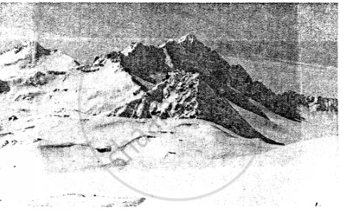
- Name the peak.
- Name the mountain range in which it lies.
Concept: undefined >> undefined
Deforestation rate in Africa is twice the average for the rest of the world with more than four million hectares of primary forest disappearing every year. What could be the reasons for this?
Concept: undefined >> undefined
The Sahara Desert forms a large part of Africa. This desert extends from the Atlantic in the west to the Red Sea in the east.
Suppose you were going to the Sahara Desert. List the things you would take with you.
What kind of problems are you likely to face?
How would you cope with them?
Concept: undefined >> undefined
Refer to the physical map of Europe in your atlas. Moving in an anti-clockwise direction starting from the Arctic Ocean and the White Sea, observe and note down the names of all the surrounding water bodies such as seas, bays, gulfs, straits, etc. Then mark each of them on an outline map of Europe.
Concept: undefined >> undefined
