Advertisements
Advertisements
Question
Study the sketch map given below and answer the questions that follow.
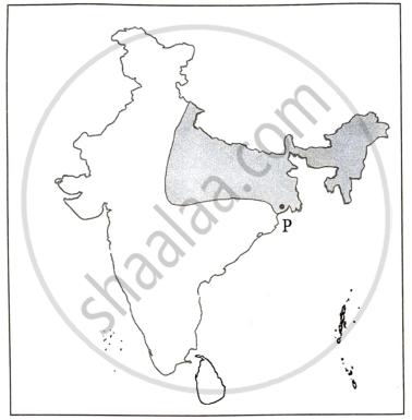
- What has led to the establishment of the port marked P? Name any two industries that have led to its further growth. [3]
- State any four reasons for the development of a planning region like the one shown above. [4]
Give Reasons
Very Long Answer
Advertisements
Solution
- The port marked by P is Paradip Port in Odisha. Paradip Port was developed to export iron ore from the mineral-rich districts of Odisha. Its strategic location near the Bay of Bengal facilitates convenient marine travel, improving trade and commercial activity in the region. Paradip Port’s growth has been driven by the iron and steel and fertilizer industries. The port plays a crucial role in these industries since it imports raw materials and exports finished items.
- The map’s shaded section shows the Chota Nagpur Plateau and neighboring mineral-rich areas in Eastern India, an important planning region. The planning region was developed for the following reasons:
- Numerous mineral resources, including coal, iron ore, and mica.
- The availability of inexpensive and skilled personnel.
- Major industries include iron and steel.
- Well-connected transportation network with railways and ports, such as Paradip.
shaalaa.com
Is there an error in this question or solution?
