Advertisements
Advertisements
Question
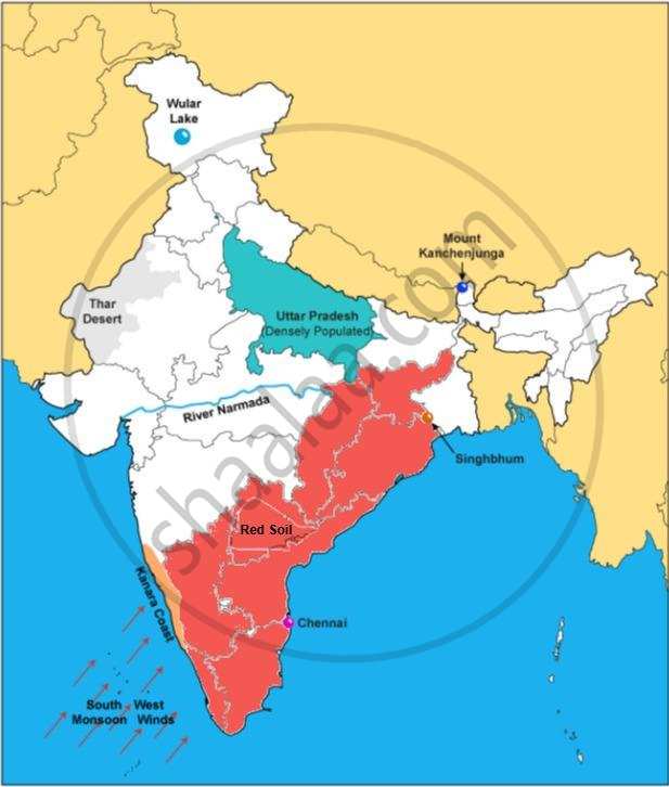
On the outline map of India provided:
- Shade and label Thar Desert.
- Label the river Narmada.
- Shade and name the Wular Lake.
- Shade and label Kanara coast.
- Mark and name Mount Kanchenjunga.
- Shade and label a densely-populated region in India.
- Shade and label a region with Red soil in India.
- Mark with a dot and name Chennai.
- Mark and label the Arabian Sea branch of S.W. Monsoon.
- Mark with a dot and name Singhbhum.
Advertisements
Solution
APPEARS IN
RELATED QUESTIONS
Name two features which makes Dantrai a more important settlement than the other settlement in the map extract.
Calculate the area of the region which lies to the south of northing 21 in square kilometres.
On the outline map of India provided:
a) Draw, name and number the Standard Meridian.
b) Label the river Yamuna.
c) Shade and label the Gulf of Khambhat.
d) Mark and name the Nathu-La Pass.
e) Mark and name the Karakoram Range.
f) Shade and name a sparsely populated State in Northeast India.
g) Shade a region with laterite soil in Eastern India.
h) Mark with a dot and name Vishakhapatnam.
i) Mark and name the winds that bring rain to West Bengal in summer.
j) Print S on the iron mines in Singhbhum.
On the outline map of India provided:
a) Mark and name Chennai
b) Label the river Godavari
c) Shade and label the Chota Nagpur Plateau
d) Shade and name the Gulf of Kachchh
e) Mark and name the Indo Gangetic Plains
f) Shade and label the area with Red Soil
g) Mark and name the winds which bring rain to Mumbai in July and August
h) Mark and name the Satpura Range
i) Mark and name Jharia Coal Field
j) Shade and label the Northern Circar coastal region.
Why is the Pamir Knot known as ‘the roof of the world’.
Why is South Asia referred as Indian Sub-continent?
On the outline map provided
(a) Label the river Chenab.
(b) Label the river Chambal.
(c) Shade and label the Nilgiri Hills.
(d) Mark and label the Eastern Ghats.
(e) Mark and name the port city of Pakistan.
(f) Mark and label Hyderabad.
(g) Shade and label the Sunderbans.
(h) Mark and name the Palk Strait.
(i) Mark and label a region North of the Tropic of Cancer where tea is grown extensively.
(j) Mark and name the winds which bring rain to Mumbai in July and August.
Name the physical divisions into which India can be divided.
On the outline map of India provided:
- Mark and label the river Krishna.
- Mark and label the Eastern Ghats.
- Shade and label a densely populated area in the southern part of India.
- Shade and label the Konkan coastal plain.
- Mark with an arrow and label the direction of western disturbance.
- Shade and label the Thar Desert.
- Shade and label the Andaman Sea.
- Mark and label the city Chennai.
- Mark and name the highest peak of Himalayas in India.
- Mark and label Mumbai High.
On the outline map of India provided:
- Shade and label an area of alluvial soil in the north-east.
- Mark using a dot and name the commercial capital of India.
- Mark and name the highest peak of the Himalayas in India.
- Shade and label Gulf of Kutch.
- Mark with arrows and name the wind bringing rainfall to Punjab in the winter.
- Shade and label a sparsely populated area.
- Mark and label Eastern Ghats.
- Mark and name a tributary of an important peninsular river.
- Mark and label the most important latitude passing through the country.
- Mark and label Coromandel coast.
