Advertisements
Advertisements
प्रश्न
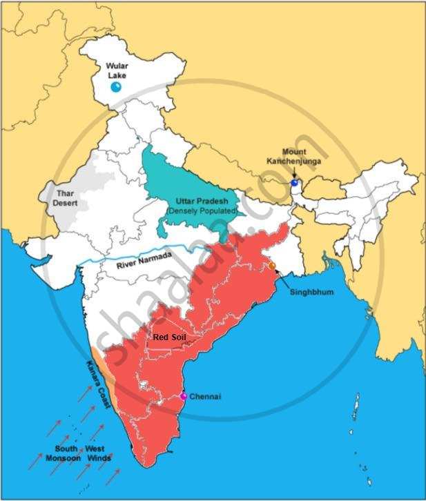
On the outline map of India provided:
- Shade and label Thar Desert.
- Label the river Narmada.
- Shade and name the Wular Lake.
- Shade and label Kanara coast.
- Mark and name Mount Kanchenjunga.
- Shade and label a densely-populated region in India.
- Shade and label a region with Red soil in India.
- Mark with a dot and name Chennai.
- Mark and label the Arabian Sea branch of S.W. Monsoon.
- Mark with a dot and name Singhbhum.
Advertisements
उत्तर
APPEARS IN
संबंधित प्रश्न
What is the value of the contour line in square 0226? What is the contour interval in the map?
What is the geographical name that you would give to the general pattern of settlement in the region shown on the map?
By what name is the parallel of latitude 23° 33′ known? Name the zones or belts into which it divides India almost equally.
Why is the Pamir Knot known as ‘the roof of the world’.
On the outline map provided
(a) Label the river Chenab.
(b) Label the river Chambal.
(c) Shade and label the Nilgiri Hills.
(d) Mark and label the Eastern Ghats.
(e) Mark and name the port city of Pakistan.
(f) Mark and label Hyderabad.
(g) Shade and label the Sunderbans.
(h) Mark and name the Palk Strait.
(i) Mark and label a region North of the Tropic of Cancer where tea is grown extensively.
(j) Mark and name the winds which bring rain to Mumbai in July and August.
On the map of India,
- Mark and name the Shiwalik Range.
- Mark and name the Western Ghats with two gaps, Bhor Ghat and Palghat Gap.
- Mark and name the peak on the Karakoram Mts, (Mt. Godwin Austien or Mt. K2).
- Mark and name, the highest peak on the Himalayas, (Mt Everest).
- Mark and name Mt. Kanchenjunga.
- Mark and name the Maikal Range.
- Shade and name the Indo-Gangetic Plain.
On the map of India, mark with a dot and name the cities.
- The National Capital (Delhi).
- The Capital of Maharashtra, or the Commercial Capital of India (Mumbai).
- The Capital of West Bengal (Kolkata).
- The Capital of Tamil Nadu (Chennai).
- The Capital of Karnataka (Bangalore).
- The Capital of Andhra Pradesh (Hyderabad).
- The city whose local time is taken as the standard time of India (Allahabad).
- Vishakhapatnam.
- Kochi.
- Capital of Jammu-Kashmir (Srinagar).
Name the physical divisions into which India can be divided.
On the outline map of India provided:
- Mark and label the Satpura.
- Shade and label the Gulf of Kutch.
- Mark and label the River Chambal.
- Mark and label Delhi.
- Mark and label 80°30' E longitude.
- Mark and label Jharia Coalfield.
- Mark with arrows and name the Southwest Monsoon winds.
- Mark and label the Karakoram Pass.
- Shade and label a sparsely populated region in Western India.
- Shade an area having Alluvial soil.
On the outline map of India provided:
- Mark and label the river Krishna.
- Mark and label the Eastern Ghats.
- Shade and label a densely populated area in the southern part of India.
- Shade and label the Konkan coastal plain.
- Mark with an arrow and label the direction of western disturbance.
- Shade and label the Thar Desert.
- Shade and label the Andaman Sea.
- Mark and label the city Chennai.
- Mark and name the highest peak of Himalayas in India.
- Mark and label Mumbai High.
