Advertisements
Advertisements
Question
Observe the map extract given below and answer the questions that follow:
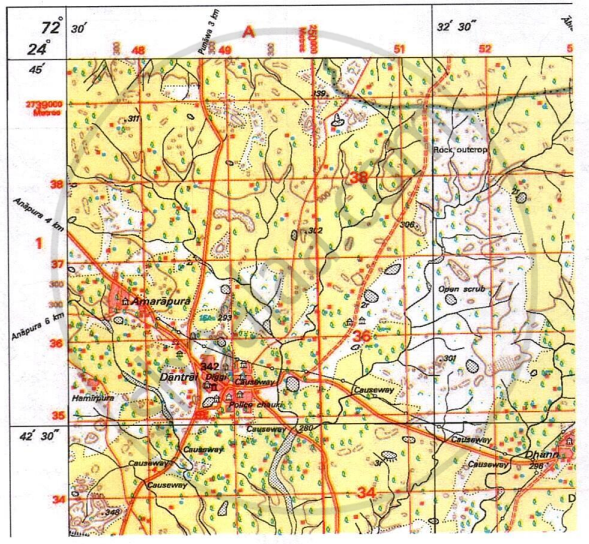
- What does the black vertical line between easting 51 and 52 represent?
- Interpret the black horizontal line between northing 34 and 35.
- What is the main mode of transport available at Dantrai?
- List the various amenities available in settlement Dantrai.
- How will the people of Dantrai cross the seasonal stream and reach the unmetalled road?
- Why do you think there are many causeways around settlement Dantrai?
- What is the significance of Diggi in 4835?
- What is the slope of the land in the given map extract? Give evidence for your answer.
Very Long Answer
Advertisements
Solution
- Longitude 72°32'30"
- Latitude 24°42'30"
- The main modes of transport available are Metalled roads - District roads.
- Post office, police chauki, hospital
- The people of Dantrai will cross the seasonal stream by using a .
- To cross the numerous seasonal streams, there are many causeways around settlement Dantrai.
- A Diggi is a traditional water tank or reservoir that stores water. In this semi-arid region with seasonal streams, its location in grid square 4835 signifies a critical source of water for drinking, domestic activities, and modest irrigation.
- The land is sloping from north to south.
Evidence: There is a decreasing pattern of spot heights from 339 in the north to 293 in the south. One more evidence is, the seasonal streams are flowing towards the south.
shaalaa.com
Is there an error in this question or solution?
