Advertisements
Advertisements
Question
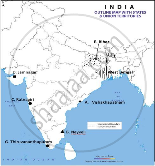
Locate and label any five of the following geographical features on the Political Outline map of India with appropriate symbols:
- An important seaport in Andhra Pradesh.
- An important coal mine in Tamil Nadu.
- Ratnagiri - iron ore mines.
- An oil refinery in Gujarat.
- The state with highest population density.
- The state leading in the production of jute.
- An international airport in Kerala.

Advertisements
Solution
- Visakhapatnam
- Neyveli
- Ratnagiri
- Jamnagar
- Bihar
- West Bengal
- Thiruvananthapuram
APPEARS IN
RELATED QUESTIONS
Which one of the following is a land locked harbour?
Distinguish between port and harbour.
Explain the meaning of the hinterland.
Name the ports of India located on the east coast.
India has ____________ major ports.
What is the cargo handling capacity of Indian ports (million tonnes)?
What is the major export from New Mangalore ports?
Which port is called the ‘Queen of Arabian Sea’?
Name the new port of India which is developed to relieve Mumbai Port.
Which of the following is not an important item which India imports from other countries?
EU stands for ____________.
Which of these port is situated at the entrance of the Zuari estuary?
Paradwip port is located in the delta of which of these rivers?
Which of the following ports is not located on the East coast of lndia?
Which one of the following is a land-locked harbour?
Which of the following is the hinterland of Kolkata port?
Match the following correctly and choose the correct answer.
| List I (Port) |
List II |
| A. Mumbai port | 1. Hughli port |
| B. Chennai port | 2. Jawaharlal Nehru port |
| C. Kolkata port | 3. Ennore port |
Examine the significance of sea ports of India in the promotion of India's foreign trade.
Why is seaport termed as gateway of international trade?
What are the advantages of sea ports for India?
