Advertisements
Advertisements
Question
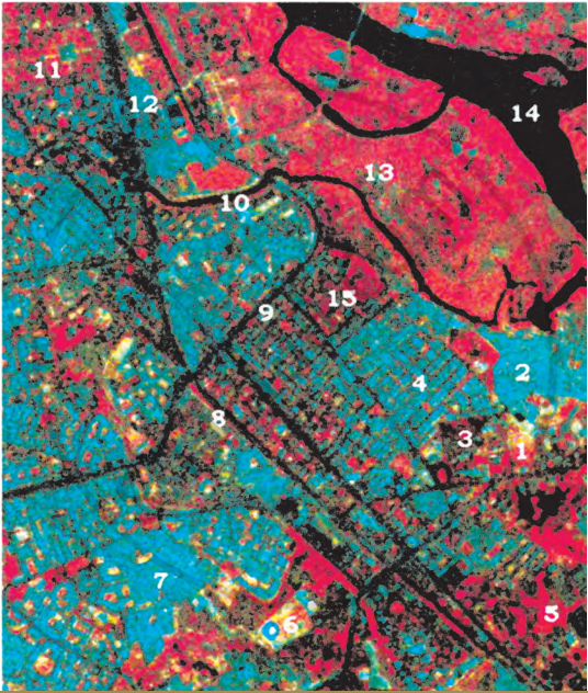
Identify various features marked on IRS IC LISS III imagery shown below. Draw clues from the description of the elements of image interpretation discussed and the colours in which various objects appear on a Standard False Colour Composite.
Activity
Advertisements
Solution
The satellite images displayed as a Standard False Colour Composite (FCC) use specific colour signatures to identify earth surface features:
- Bright Red / Magenta: Healthy vegetation, forests, and cropped land.
- Dark Blue to Black: Clear water bodies.
- Light Blue: Turbid water, river sand, or low-density built-up/residential areas.
- Dark Blue to Bluish Green: High-density urban/built-up areas.
Identification of Numbered Features (IRS IC LISS III Imagery)
- 1 & 6 (Bright White / Cyan Spots): High-density built-up structures, commercial centers, or industrial installations.
- 2, 4, 7, 11 & 12 (Light Blue / Cyan Grid Areas): Low-density built-up areas, planned residential colonies, or urban settlement grids.
- 3 (Mixed Tone / Light Blue with Dark Patches): Urban parks, open spaces, or transitional scrub land within the city layout.
- 5, 13 & 15 (Bright Red to Magenta Patches): Healthy vegetation, dense tree cover, forest patches, or lush agricultural/cropped lands.
- 8 & 9 (Dark Linear Features): Major linear transportation routes such as highways, arterial roads, or railway lines cutting across the terrain.
- 10 (Sinuous Light/Dark Feature): A minor river channel, stream, or drainage canal passing through the area.
- 14 (Dark Blue to Black Zone): A major water body, river basin, or reservoir showing strong infrared absorption.
shaalaa.com
Is there an error in this question or solution?
