Advertisements
Advertisements
Question
Refer to the given outline Map of India and attempt subparts (i) and (ii) on map only.
- Mark and label the following on the outline Map of India.
- The northern most Trans-Himalayan Mountain range.
- The coastal plain, which runs from the south of Goa to Kanyakumari.
- The largest salt water lake on the eastern coast.
- Label the following on the outline Map of India.
- The north terminal of the ‘North-South Corridor’ marked S is ______.
- The river which originates near Mahabaleshwar marked W is ______.
- The state in India with the highest literacy marked T is ______.

Fill in the Blanks
Map
Advertisements
Solution
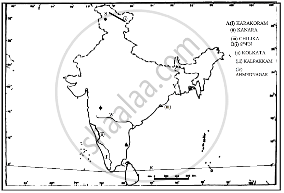
-
- Karakoram
- Kanara
- Chilika
- The north terminal of the ‘North-South Corridor’ marked S is Srinagar.
- The river which originates near Mahabaleshwar marked W is R. Krishna.
- The state in India with the highest literacy marked T is Kerala.
shaalaa.com
Sketch Maps
Is there an error in this question or solution?
