Advertisements
Advertisements
Question
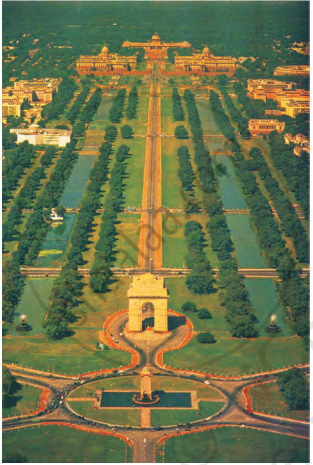
Here is a photograph was taken from a helicopter. You can see Rajpath — the road which joins India Gate to Rashtrapati Bhawan. Mark where on Rajpath will Aditi be.

Match the map and the photo
- Have you seen a map of a city? Look at Map. Match it with the photo and find out where India Gate is. Draw it on the map.
- Some roads are shown in this part of the map. Look for them in the photo.
- Name roads that you will cross on your way from Rashtrapati Bhawan to India Gate.
- Look for the National Stadium in Map 1. Can you see it in the photo?
Diagram
Map
Advertisements
Solution
- Yes, I have seen a map of a city. After matching the map with the photo, we can find the position of India Gate as shown below.
- The roads shown on the map are clearly visible in the photo.
- On my way from Rashtrapati Bhavan to India Gate, I have crosses the following roads: Rafi Marg, Janpath, and Man Singh Road.
- The National Stadium is seen in Map 1, but cannot be seen in the photo.
shaalaa.com
Map
Is there an error in this question or solution?
APPEARS IN
RELATED QUESTIONS
If we zoom in to look more closely at one part of the map, it looks like this.

Look at the shape of the yellow area. Have you seen this shape before? How many sides does it have?
If you are walking on Rajpath then after India Gate on which side would Children's Park be?
Which of these roads make the biggest angle between them?
Trace the route of the parade in Map 3 and mark India Gate and Rajpath.

Look at the map carefully and find out:
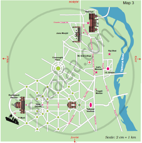
- Which of these is the longest road?
Look at the map carefully and find out:

- The total route of the parade is about how long?
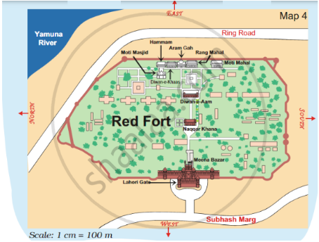
- Which of these is nearer to river Yamuna? – the Diwan-e-Aam or the Diwan- e-Khaas?

- Between which two buildings is Aaram Gah?

- Which buildings do you pass while going from Rang Mahal to the Hammam?

- About how far is Lahori Gate from Diwan-e-Khaas?
