Advertisements
Advertisements
Question
Give reason as to why.
Parts of Rajasthan, Gujarat and the leeward side of the Western Ghats are drought-prone.
Advertisements
Solution
Parts of Rajasthan, Gujarat and the leeward side of the Western Ghats are drought-prone because of the scanty rainfall received by these regions during the monsoon rains. The progressive decrease in the humidity of the winds of the Bay of Bengal branch causes the amount of rainfall to decrease from east to west in northern India. As the leeward side is the rain-shadow area, the regions lying in this region receive very little rain from the Arabian Sea branch. It is the windward side of the Ghats that receives the maximum rain.
APPEARS IN
RELATED QUESTIONS
Choose the right answer from the alternative given below.
Which one of the following places receives the highest rainfall in the world?
Match the following.
| 1. | The north-east monsoon season | cotton |
| 2. | The cold weather season | North eastern India |
| 3. | Regur soil | October- November |
| 4. | Burst of Monsoons | December-February |
| 5. | Norwester | Kerala |
Match the following.
| 1. | Rubber and Mahogany | Western Himalayas |
| 2. | Sandwood and rosewood | Eastern Himalayan Forest |
| 3. | Oak, birch, Silver | Coastal forest |
| 4. | Casurina, Palm and coconut | Deciduous forest |
| 5. | Sal, Semal, Jamun and Jujube | Evergreen forest |
Match the Column I with Column II.
| Column I | Column II | |
| A. | Western Disturbance | Driest place on Earth |
| B. | Norwesters | North East monson |
| C. | Burst of monsoon | Bihar- Assam |
| D. | Cyclonic Depression | Marine Biosphere Reserve |
| E. | Gulf of mannar | South west monsoon |
| F. | Atacama desert | Punjab - Haryana |
What are the main causes that have created a major threat to the natural environment?
Why does the coromandal coast face frequent cyclones?
On an outline map of India, show the following.
- Areas receiving rainfall over 400 cm.
- Areas receiving less than 20 cm of rainfall.
- The direction of the south-west monsoon over India.
Collect photographs of typical rural houses and clothing of people from different regions of India. Examine whether they reflect any relationship with the climatic condition and relief of the area.
Observe the following graph and answer the questions given below:
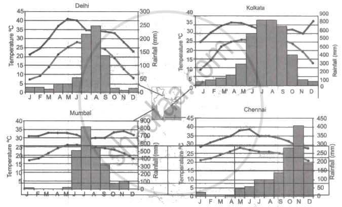
Note: In the graphs, the dark line represents the max. temperature and the lighter line represents min. temperature. The bars represent the amount of rainfall every month in each city.
- Where in the four cities is the rainfall heaviest?
- Which city has the most rainfall throughout the year?
- Which city experiences the highest temperature?
- Calculate the average range of minimum and maximum temperature for all four cities.
- What do the temperature curves in Delhi indicate?
- What is the condition of Mumbai during monsoons?
Why houses in Assam are built on stilts?
