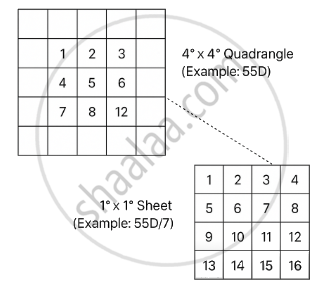
India’s topographical maps, prepared by the Survey of India, follow a grid-based nomenclature system based on the International Map of the World (IMW). The country is divided into 4° x 4° quadrangles (e.g., 55D), each subdivided into 16 smaller 1° x 1° degree sheets, numbered 1–16 in a standard grid pattern. These sheets are further split for larger-scale mapping, ensuring systematic coverage, uniformity, and easy referencing for various uses like planning, development, and defence.