Advertisements
Advertisements
प्रश्न
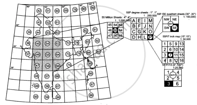
Give a summary of dimension and scale of topographical maps.
Advertisements
उत्तर
APPEARS IN
संबंधित प्रश्न
What are the following?
The black vertical line between eastings 09 and 10
Give the six figure grid reference of lined well near Chekhla.
Give four grid reference of each of the following:
1) Open scrub
2) Bantawada
What type of rainfall is experienced in the region shown in the map extract? Justify your answer giving one reason.
What do you understand by the term Grid?
What is a Fire line?
What do you mean by ‘Marginal Information’?
Answer the following questions on the Survey Sheet Number 45 D/10. Eastings 00 to 10; Northings 17 to 28. (Map G)
(a) Give four-figure grid references of the following:
(i) Dhad Talao (ii) Sheet rock in the North-east
(iii) Rock outcrop in the North (iv) Stony waste in the South-east
(v) Open scrub south of Dhad Talao
(b) Give the six-figure grid references of the following:
(i) Police Chowki in village Dantral
(ii) Temple in Bhamra village
(iii) Well with water in settlement Devka
(iv) Spot height 310 near village Jolpur
(v) Tank near Indaria settlement
(c) Give-the direction of the following:
(i) Village Dantral (0324) from Dhann (0723)
(ii) Village Bhamra (0521) from Dhann (0723)
(iii) Village Jolpur (0718) from Malawa (0519)
(iv) Village Warka (0716) from Bikanwas (0316)
(v) Village Rampura (0617) from Dhann (0723)
(d) Give the meanings of the following:
(i) 15r in blue in grid square 0224.
(ii) 300 in brown in grid square 0426.
(iii) Black line in the northernmost part of the map.
(iv) Red line in grid square 0819.
(v) Black dots in grid square 0617.
(e) Give the settlement patterns of the following:
(i) Village Dhann (ii) In grid square 0220
(f) Measure the distances of the following:
(i) Direct distance in km. from Indaria (0826) to Jolpur (0718)
(ii) Indirect distance in km. along the cart track from Dantral (0324) to Dhann (0723)
(g) Give the drainage patterns of the following:
(i) 0827 (ii) In grid square 0226
(h) Name three man-made features found in grid square 0419 and draw their symbols.
(i) Give two evidences that the region gets seasonal rainfall.
(j) Explain the nature of the river.
(k) Explain the relief of the area.
(l) What is the general slope of the land? Give reason for your answer.
(m) What is the main occupation of the people? Give reason for your answer.
(n) What is the mode of irrigation? Give reasons for your answer.
(o) What is the mode of transport? Give reasons for your answer.
Answer the following questions on the Survey Sheet Number 45 D/7.
(a) Give six figure grid references of the following:
(i) ∆ 364 (ii) The temple at Rampura
(b) Mention any two features seen in the map extract which show that the region has seasonal rainfall
(c) Calculate the distance in kilometres along the cart-track linking Juvol (923826) and Amiwada (944817).
(d) Which is the chief form of irrigation shown in the map extract? Give an evidence to justify your answer.
(e) Give one reason to explain why the streams in grid square 9478 do not join a river. Identify another grid square in the map extract that has similar streams.
(f) What do the following represent:
(i) Black broken lines in 9575 (ii) Black curved lines in 9879.
(g) Identity two landforms shown by the contours in grid square 9876.
(h) (i) What is the general direction of the Balram Nadi?
(ii) Which bank of the main river does the Balram Nadi join?
(i) What is the main occupation of the people living in the area shown in the map extract? Give one reason to support your answer.
(j) What is meant by scale of a map? What is the scale of the map extract provided to you?
Write short note on ‘Marginal Information’ in Topographical sheets.
