Advertisements
Advertisements
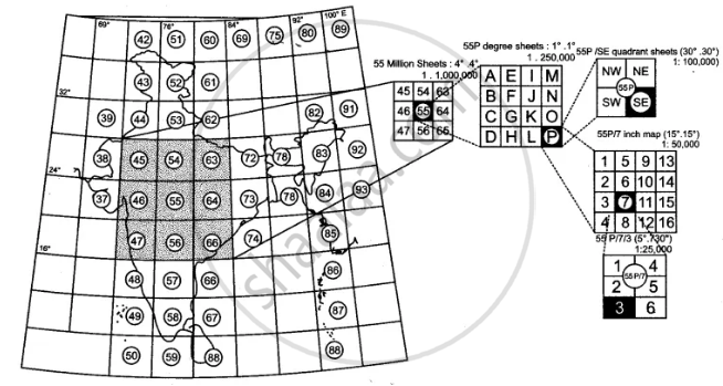
प्रश्न
Give a summary of dimension and scale of topographical maps.
Advertisements
उत्तर
APPEARS IN
संबंधित प्रश्न
What does the blue coloured circle in the grid square 0619 represent?
Mention one man-made feature in the map, which also provides evidence that the rainfall is seasonal.
Give the six figure grid reference of Triangulated height 217
What do you understand by a causeway?
What do you mean by ‘Marginal Information’?
Study the extract of the Survey of India Map sheet No. 45D/10 and answer the following questions:
(a) Give the six figure grid reference of:
(i) the brick kiln
(ii) the temple near Asav.
(b) What is the difference in the pattern of drainage in grid square 0916 and in 0712?
(c) Give the four figure grid reference of each of the following:
(i) Stony waste
(ii) Open scrub.
(d) Calculate the distance in kilometres along the metalled road between the causeways in grid square 0512 and 0808.
(e) (i) What do the tiny curved black lines in grid square 0315 indicate?
(ii) What is the main cause for this feature?
(f) (i) What is the geographical name that you would give to the general pattern of settlements in the region shown on the map?
(ii) Give a reason for your answer.
(g) What is the general direction of flow of the Sipu Nadi, given in the map extract? Give a reason to support your answer.
(h) Name two probable occupations of the people in the settlement of Revdar in grid square 0313 and 0413.
(i) What kind of roads connect (i) Marol with Mitan and (ii) Revdar with Karaunti respectively?
(j) Give two reasons to show that the area depicted in the map experiences seasonal rainfall.
Study the extract of the Survey of India Map Sheet No. 45D/10 and answer the following questions: (Map G)
(a) Give the four-figure grid reference of:
(i) Dadarla (ii) Bhamra
(b) Which is the largest settlement shown on the map extract? Which one communication facility is exclusively available to this settlement?
(c) What does RF stand for? State the RF of the map provided to you.
(d) What is the total area of the actual ground represented in the map extract? (Show with the help of a simple calculation)
(e) What is meant by ‘contour interval’? State the contour interval of the toposheet provided to you
(f) State the highest and the lowest spot heights found on the map extract. Also mention whether they are in metres or in feet.
(g) Give the six-figure grid reference of:
(i) Spot height 339 (ii) Permanent hut located near Dhad Talao.
(h) What, according to you is the main (i) occupation, and (ii) religion of the people of the above area?
(i) Name one ‘natural’ and one ‘man-made’ source of irrigation used in this region.
(j) Name the general mode of transportation used in this region. What special feature of this mode is mentioned in the map extract?
Study the extract of the Survey of India Map Sheet No. 45 D/7 (A and B) and answer the following questions.
(a) Give the six figure grid reference of
(i) ∆ 277 (→) (ii) Lime kiln near Rampura (→) (iii) Stony waste (→).
(b) (i) What does the blue line in the Sipu river indicate?
(ii) In which village do you see the nodal function 7 What do you mean by this?
(c) (i) What does the black lines along the streams in the grid square 9199 indicate?
(ii) How are these features formed?
(iii) What type of region is shown in grid square 8696?
(d) Give the six-figure grid reference of the following:
(i) Lime Kiln near village Panswala.
(ii) Well with water near village Gonodara.
(iii) Dry tank near village Mohudi Moti.
(e) (i) What is the direction of the flow of Sipu river?
(ii) State why does it flow in this particular direction?
(f) Mention three natural features in the grid square 8998.
(g)
(i) What is the meaning of the term open scrub printed on the map.
(ii) How do you get an idea of the general nature of the slope in this area?
Study the extract from the topographical sheet No. 63K/12, as shown in the figure below and answer the following questions-
- Convert 1:50,000 into a statement of scale.
- Name the major settlements of the area.
- What is the direction of flow of the river Ganga?
- At which one of the banks of river Ganga, Bhatauli is located ?
- What is the pattern of rural settlements along the right bank of river Ganga?
- Name the villages/settlements where Post Office is located ?
- What does the yellow colour in the area refer to?
- What means of transportation is used to cross the river by the people of Bhatauli village?

R. F. 1: 50,000
Part of the Topographical Sheet No 63K/12
Identify the survey sheet of your city. Make a list of the important features both man-made and natural.
