Please select a subject first
Advertisements
Advertisements
Briefly describe the climate and vegetation of the south-eastern and south-western coasts of Australia.
Concept: undefined >> undefined
What are marsupials? Describe any one marsupial.
Concept: undefined >> undefined
Advertisements
What are monotremes? Give examples.
Concept: undefined >> undefined
Study the map given here and answer the questions (lines indicate the different climatic regions)
- Describe the vegetation of region C.
- What are the most outstanding characteristics of the climate of region B?
- On the map, draw the South-East Trade Winds with red
- By what name are the temperate grasslands known in the Murray-Darling Basin? Write the name in the appropriate place on the map.
Concept: undefined >> undefined
This is a photograph of a eucalyptus tree, a common tree found in Australia. There are over 900 species of this tree in Australia.
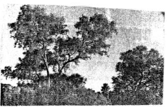
- What is the local name of this tree?
- Which animal survives by eating the leaves of this tree?
Concept: undefined >> undefined
Contour lines on a map join points of equal ______ on the surface or the earth above or below a reference point.
Concept: undefined >> undefined
What is a contour line?
Concept: undefined >> undefined
How does relief of an area affect land use?
Concept: undefined >> undefined
Why do you think that the knowledge of scale is important for reading a map?
Concept: undefined >> undefined
Choose the correct answer:
This scale is stated in words
Concept: undefined >> undefined
State whether the following is true or false.
The verbal scale is stated in words.
Concept: undefined >> undefined
State whether the following is true or false.
A statement scale consists of a straight line which is divided into lengths.
Concept: undefined >> undefined
What is meant by the scale of a map?
Concept: undefined >> undefined
Which three ways are used to represent the scale of a map?
Concept: undefined >> undefined
Convert the statement scale 1 cm = 100 km into R.F. scale.
Concept: undefined >> undefined
What method would you use to measure the length of a river?
Concept: undefined >> undefined
Describe any two ways of representing a map scale.
Concept: undefined >> undefined
Look at the picture and answer the question

What type of scale is shown alongside?
Concept: undefined >> undefined
Look at the picture and answer the question
State a feature of this scale.
Concept: undefined >> undefined
Look at the plan of a school given here and note the scale given at the top of the plan : 1 cm to 8 m. This verbal scale means that 1 cm on the paper represents 8 m on the ground. Use this scale to find out the length and breadth of the different places shown in the plan.
Concept: undefined >> undefined
