The road from the Police Station at Dantiwada to the settlement of Nandotra (Brahmanvas) is a pack track with a pass. It is a shorter route but cannot be used during the rainy season. This path is mainly used by pack animals, groups of people, or both.
Advertisements
Advertisements
Question
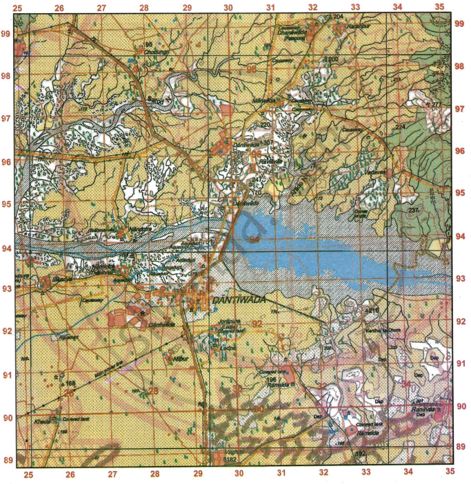
Study the extract of the Survey of India map Sheet No. G43S7 and answer the following questions: [Eastings 25-35, Northings 89-99]:
-
- Give the four-figure grid reference of the settlement at Lodpa.
- Give the six-figure grid reference of the spot height •172.
-
- Identify the features from the conventional signs, the six-figure grid reference of which is 332963.
- Give the compass direction of Ramsida from Nandotra.
-
- Measure the length in kilometres of the masonry dam on the main river in the given map extract.
- Identify the type of road that runs from the Police Station at Dantiwada up to the settlement at Nandotra (Brahmanvas) (grid square 2794). For which purpose is this road used?
-
- Calculate the area of the region in sq. km, enclosed within the Eastings 25-35 and Northings 91 to 95.
- State the three types of roads seen in the given map extract. What do they reflect on the type of settlements in the region in the given map extract?
-
- State the difference in the pattern of settlement at Dantiwada on the right bank of the main river and the one on the left bank of it.
- What is the main form of irrigation in the area north of Sarod Nala? From what can you infer this source of irrigation?
Very Long Answer
Advertisements
Solution
-
- 2991
- 265972
-
- Chhatri
- Ramsida is located to the south-east of Nandotra.
-
- The map distance is 3.6 cm and the scale is 2 cm = 1 km; therefore, the dam’s length is 1.8 km.
-
-
- The total number of grid squares enclosed between Eastings 25 to 35 and Northings 91 to 95 is 40. Since each grid square covers an area of 1 km × 1 km, the total area of 40 grid squares is 40 sq. km.
- The given map extract shows three types of roads: metalled roads, cart tracks, and pack tracks. This indicates that well-developed settlements such as Dantiwada, Dhanawad, Jorapura, and Marwada are linked by metalled roads and may be towns or cities. In contrast, smaller settlements, likely villages, are connected by cart tracks and pack tracks.
-
- Dantiwada, located on the left bank of the main river, shows a mainly linear settlement pattern along the metalled road, while Dhantiwada on the right bank has a clustered settlement pattern.
- Lined perennial wells serve as the primary source of irrigation in the region north of Sarod Nala, as indicated by their conventional symbols on the map. The existence of these wells, along with the yellow wash shown in the map extract, suggests that agriculture is the main occupation of the people in this area.
shaalaa.com
Is there an error in this question or solution?
