Advertisements
Online Mock Tests
Chapters

Advertisements
Solutions for Chapter 7: Region and Regional Development
Below listed, you can find solutions for Chapter 7 of Maharashtra State Board Balbharati for जिओग्राफी [इंग्रजी] इयत्ता १२ महाराष्ट्र राज्य मंडळ.
Balbharati solutions for जिओग्राफी [इंग्रजी] इयत्ता १२ महाराष्ट्र राज्य मंडळ 7 Region and Regional Development Intext Questions [Pages 66 - 74]
Try this.
Given below are some geographical areas given to you. Complete the table in your notebook thinking about similarities between them and their types. One has been done for you as an example. Answer the questions that follow:
| Geographical areas | Common factors/characteristics | Type |
|---|---|---|
| Ganga river basin, Amazon river basin, Mississippi river basin, Nile river basin | River basins | Physical |
| Himalayan region, Alps, Western Ghats, Rockies, Caucasus | ||
| Marathwada, Vidarbha, Khandesh, Konkan, Western Maharashtra | ||
| Thar Desert, Arabian Desert, Gobi Desert, Sahara Desert | ||
| Rajasthan, Madhya Pradesh, West Bengal, Kerala, Manipur | ||
| Pune, Bhopal, New York, Manchester, Munich, Shanghai | ||
| Parbhani, Nagpur, Palghar, Kolhapur, Solapur | ||
| Hindi-speaking belt, Bengali-speaking belt, Marathi-speaking belt, Kannada-speaking belt, Urdu-speaking belt | ||
| Delhi University campus, Punjab University campus, Mumbai University campus, Vanasthali University campus |
- While completing the above table, how did you decide the common factor between these areas?
- How did you differentiate one area from another?
- Is the common factor the only basis of differentiation?
- Make a list of characteristics which can be the basis of different areas separately.
Do you know?
The States Reorganization Act of 1956 made the state boundaries according to languages after independence. Thus, Maharashtra became the State of Marathispeaking people, Tamilnadu became the land of Tamil-speaking people, etc.
Use your brain power !
Can you tell what is the identifying characteristic in the following regions?
- Pune Metropolitan Region
- Nagpur hub
- Dal Lake in Srinagar
- Alleppey tourism centre
Try this.
Here is a list of regions. Classify them into Formal or Functional regions:
Ujani Dam catchment area, area served by Pune Municipal Transport (PMT), area served by Citi Cable Service, Uttar Pradesh, District Kolhapur, Taluka Haveli, rice – producing region of Konkan, Black cotton soil region of India, areas served by Local trains of Mumbai, area served by a Primary Health Centre.
| Formal Regions | Functional Regions |
Identify your formal region.
Can you identify and demarcate your own functional region?
Which one is larger?
Can you tell?
Read the table and answer the questions that follow:
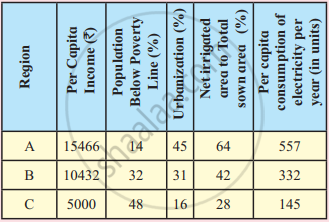
- In which region do you think there are more resources available?
- In which region do you think people are richer?
- In which region do you think people may be more happier? Why?
- Do you think the given indicators or factors are enough to decide the standard of living of people in the region?
- In which region would you like to stay and why?
Think about it.
Does development mean maximum utilisation of resources?
Does development consider environment as an indicator?
Can a region be called developed if it has sparse population or no population?
Discuss this in your class.
Try this.
In the following table, regions are given. At the same time, some geographical factors and effects are also given. Complete the table accordingly, with the help of solved examples.
| Region | Geographical Factors | Effects on the region |
| Nile River basin | Agricultural Development, Development of Industries, Hydroelectricity project, Irrigation etc. | |
| Coniferous forest area | ||
| Japan | Island location, low mineral resources, narrow geographical extent | |
| Indonesia, Malaysia | Agriculture Development, Trade,Tourism |
Can you tell?
Looking at the five stages of Demographic Transition Theory, countries in which stage do you think, will be called developed?
Having looked at the various shapes of pyramids, which pyramid will represent a developed country? (fig.)
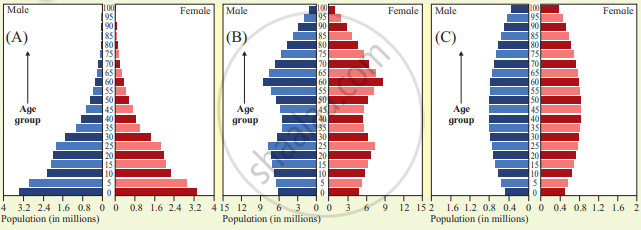
After having answered both the questions above, what can you comment upon the role of population in regional development?
| Region | Percentage of malnourished children about to enter school | Government expenditure on education (% of total budget) |
| Year 2016 | Year 2016 | |
| A | 29.3 | 4.70 |
| B | 19.2 | 4.17 |
| C | 3.4 | 7.10 |
| D | 12.8 | 5.40 |
| E | 31.7 | 4.09 |
| F | 27 | 4.45 |
| G | 3.1 | 3.82 |
| H | 5.9 | 5.95 |
Draw a conclusion on the basis of the data given in table. Use Spearman's Rank Correlation, find the correlation between the two variables. What can you comment about the development in this region?
Try this.
Look at the land use of the following regions and answer the questions that follow:
| Region | Arable land (%) | Land under permanent crops (%) | Land under permanent meadows and pastures (%) | Land under Forests (%) | Other land (%) | GDP in billion dollars (2017) |
| A | 11.8 | 0.3 | 46.0 | 2.1 | 39.9 | 76.48 |
| B | 4.0 | 0.04 | 44.0 | 20.1 | 32.1 | 1364.83 |
| C | 52.0 | 16.0 | 4.1 | 9.7 | 17.9 | 837.58 |
| D | 27.4 | 0.8 | 15.3 | 22.4 | 32.6 | 567.48 |
| E | 6.5 | 1.0 | 16.7 | 57.0 | 19.2 | 3456.35 |
| F | 57.8 | 0.6 | 5.5 | 14.3 | 21.8 | 312.84 |
| G | 2.8 | 1.0 | 0.0 | 0.1 | 95.6 | 1391.25 |
| H | 33.6 | 1.8 | 16.8 | 31.0 | 16.4 | 3061.14 |
| I | 50.1 | 4.1 | 3.1 | 21.8 | 20.8 | 11325.66 |
| J | 13.7 | 13.0 | 5.7 | 48.5 | 19.0 | 3737.48 |
| K | 11.0 | 0.8 | 2.6 | 66.0 | 19.7 | 5747.49 |
| L | 2.5 | 0.5 | 37.5 | 37.7 | 21.8 | 206.22 |
- What does the table show?
- Which region has the highest land use under agriculture?
- Which region has the highest GDP?
- Which country has more land use under forests?
- Which region has highest land use under the category ‘other land’? What is its GDP?
- Write your conclusion in few sentences.
Look at the following data and answer the questions that follow:
| Regions | Contribution of Primary Sector to GDP (%) | Contribution of Secondary Sector to GDP (%) | Contribution of Tertiary Sector to GDP (%) | Human Development Index (HDI) |
| 2018 | 2018 | 2018 | 2018 | |
| A | 1 | 34 | 65 | 0.93 |
| B | 2 | 32 | 66 | 0.85 |
| C | 2 | 37 | 61 | 0.71 |
| D | 6 | 33.2 | 60.8 | 0.81 |
| E | 14 | 30 | 56 | 0.65 |
- In which region is contribution of primary activities the least?
- In which region is contribution of primary activities the most?
- In which region is contribution of tertiary activities the most?
- Which region has the highest HDI?
- Can you draw a conclusion on the basis of the answers from Q1 to Q4?
Give it a try.
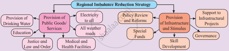
Go through the fig. and write two sentences on each factor. Tell how they will help in reducing regional imbalance. Also add some more to the list, if necessary.
Find out !
Find out information about ‘Human Happiness Index’. Relate its correlation with regional development and discuss in the class.
Balbharati solutions for जिओग्राफी [इंग्रजी] इयत्ता १२ महाराष्ट्र राज्य मंडळ 7 Region and Regional Development Exercise [Page 74]
Identify the correct group or factor:
Satpura - Deccan - Alps - Rockies
Yavatmal - Amravati - Solapur - Greater Mumbai
Thar - Sahara - Himalaya - Gobi
Marathwada - Khandesh - Vidarbha - Konkan
Identify the correct group or factor.
Plain - Lake - Mountain - Plateaus
Pressure - Rivers - Temperature - Humidity
Tropical forest - Thorny forest - Mangrove forest - Deciduous forest
Fishing - Lumbering - Agriculture - Bakery
Differentiate between formal regions and functional regions.
Differentiate between physical regions and political regions.
Write short notes on:
Factors affecting regional development
Write a short note on:
Measures to reduce regional imbalance.
Give geographical reasons:
Regional development is dependent on physical setting.
Give geographical reasons:
Factors like illiteracy, poverty affect the regional development.
Give geographical reasons:
Development is very less in the mountain region of Himalaya.
Answer in details:
What is a region?
On what factors are the regions differentiated? Give examples.
Per capita income is not the real indicator of regional development. Explain.
Find the correlation between land under permanent crops and GDP given in the table using Spearman’s Rank Correlation. Write the conclusion in your own words:

Solutions for 7: Region and Regional Development
Balbharati solutions for जिओग्राफी [इंग्रजी] इयत्ता १२ महाराष्ट्र राज्य मंडळ chapter 7 - Region and Regional Development
Shaalaa.com has the Maharashtra State Board Mathematics जिओग्राफी [इंग्रजी] इयत्ता १२ महाराष्ट्र राज्य मंडळ Maharashtra State Board solutions in a manner that help students grasp basic concepts better and faster. The detailed, step-by-step solutions will help you understand the concepts better and clarify any confusion. Balbharati solutions for Mathematics जिओग्राफी [इंग्रजी] इयत्ता १२ महाराष्ट्र राज्य मंडळ Maharashtra State Board 7 (Region and Regional Development) include all questions with answers and detailed explanations. This will clear students' doubts about questions and improve their application skills while preparing for board exams.
Further, we at Shaalaa.com provide such solutions so students can prepare for written exams. Balbharati textbook solutions can be a core help for self-study and provide excellent self-help guidance for students.
Concepts covered in जिओग्राफी [इंग्रजी] इयत्ता १२ महाराष्ट्र राज्य मंडळ chapter 7 Region and Regional Development are Overview of Region and Regional Development, Types of Regions, Regional Development, Factors Affecting Regional Development, Physical Factors and Regional Development, Population and Regional Development, Land Use and Regional Development, Regions, Primary, Secondary, and Tertiary Economic Activities and Regional Development, Regional Imbalance, Causes of Regional Imbalances in India, Strategies to Reduce Regional Imbalance.
Using Balbharati जिओग्राफी [इंग्रजी] इयत्ता १२ महाराष्ट्र राज्य मंडळ solutions Region and Regional Development exercise by students is an easy way to prepare for the exams, as they involve solutions arranged chapter-wise and also page-wise. The questions involved in Balbharati Solutions are essential questions that can be asked in the final exam. Maximum Maharashtra State Board जिओग्राफी [इंग्रजी] इयत्ता १२ महाराष्ट्र राज्य मंडळ students prefer Balbharati Textbook Solutions to score more in exams.
Get the free view of Chapter 7, Region and Regional Development जिओग्राफी [इंग्रजी] इयत्ता १२ महाराष्ट्र राज्य मंडळ additional questions for Mathematics जिओग्राफी [इंग्रजी] इयत्ता १२ महाराष्ट्र राज्य मंडळ Maharashtra State Board, and you can use Shaalaa.com to keep it handy for your exam preparation.
