Advertisements
Advertisements
प्रश्न
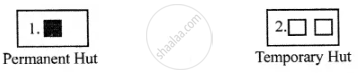
Look at the symbols given here and answer the following question.
What does symbols 1 and 2 show?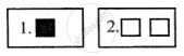
Advertisements
उत्तर
APPEARS IN
संबंधित प्रश्न
Choose the correct answer
The numerator of a representative fraction is always
Answer the following question in one or two paragraphs.
Why is the key or legend an important element of a map?
Answer the following question in one or two paragraphs.
What is the grid system ? Why is it important?
Fill in the blank
Roads, rail tracks, wells, etc. are ________ features on a map.
Your friend has invited you to his house. He has drawn a rough sketch on a paper showing the direction to his house for you.
How does the sketch help you? What quality of your friend is shown through in this gesture?
Choose the odd one
Write a note on conventional signs and symbols.
What are the colours used in the maps?
In general, maps are drawn with ______ orientation.
The features of ______ colour in Map is Forest.
