Advertisements
Advertisements
प्रश्न
Give geographical reason:
Convectional type of rainfall is not prominent in India.
Advertisements
उत्तर
- A convectional type of rainfall is experienced in the equatorial region.
- Air near the equatorial region is heated more due to high-intensity solar radiation. It expands, becomes lighter and moves in the upward direction in the form of convectional currents. The rising air cools down. Relative humidity increases and condensation begins. Clouds are formed and every day in the evening, the equatorial regions get a convectional type of rainfall.
- India is not an equatorial country and the topography of India is the main reason of orographic rainfall in India.
Therefore, convectional type of rainfall is not prominent in India.
संबंधित प्रश्न
Choose the right answer from the alternative given below.
Monsoon arrives in India approximately in
These forests are found along the rivers on Khadar areas:
Shrub vegetation is found in ______.
Match the following.
| 1. | Rubber and Mahogany | Western Himalayas |
| 2. | Sandwood and rosewood | Eastern Himalayan Forest |
| 3. | Oak, birch, Silver | Coastal forest |
| 4. | Casurina, Palm and coconut | Deciduous forest |
| 5. | Sal, Semal, Jamun and Jujube | Evergreen forest |
Match the Column I with Column II.
| Column I | Column II | |
| A. | Tropical evergreen forest | Sandal wood |
| B. | Tropical Deciduous forest | Oak, silver fir |
| C. | Alpine forest | Black buck |
| D. | Tidal forest | Casuarina |
| E. | Coastal forest | Mahogany |
| F. | State animal of Andhra Pradesh, Pujab and Haryana | Mangrove trees |
What kind of Vegetation is supported by the sandy soil of the desert?
On an outline map of India, show the following.
- Areas receiving rainfall over 400 cm.
- Areas receiving less than 20 cm of rainfall.
- The direction of the south-west monsoon over India.
Mark the following in the outline map of India supplied to you. Write the names. Give Index
- Sikkim
- Lakshadweep Island
- Chennai Port
- Mineral oil refineries in Assam-Digboi
- Any one southern state with high density of population
- Tropic of Cancer
India's climate is of ______ type.
Observe the following graph and answer the questions given below:
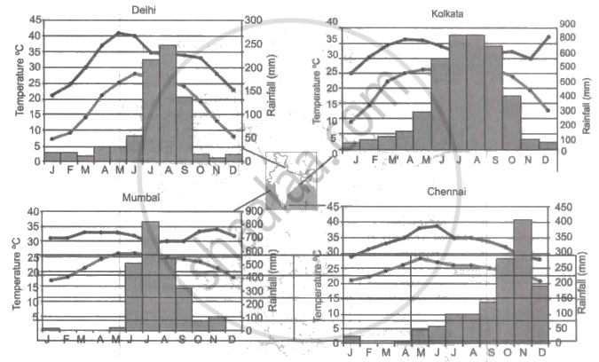
Note: In the graphs, the dark line represents the max. temperature and the lighter line represents min. temperature. The bars represent the amount of rainfall every month in each city.
- Where in the four cities is the rainfall heaviest?
- Which city has the most rainfall throughout the year?
- Which city experiences the highest temperature?
- Calculate the average range of minimum and maximum temperature for all four cities.
- What do the temperature curves in Delhi indicate?
- What is the condition of Mumbai during monsoons?
