Advertisements
Advertisements
Explain the natural factors affecting the location of human settlements.
Concept: undefined >> undefined
Explain how human settlements have evolved.
Concept: undefined >> undefined
Advertisements
Differentiate between a hamlet and a village.
Concept: undefined >> undefined
Identify the type of human settlement from the following statement.
Their money and time are saved by living on the farm.
Concept: undefined >> undefined
Identify the type of human settlement from the following statement.
There is a lot of social life in this settlement.
Concept: undefined >> undefined
Identify the type of human settlement from the following statement.
Shops are located on both the sides of the road
Concept: undefined >> undefined
Identify the type of human settlement from the following statement.
This settlement is found at the foothills of mountains or along the coast.
Concept: undefined >> undefined
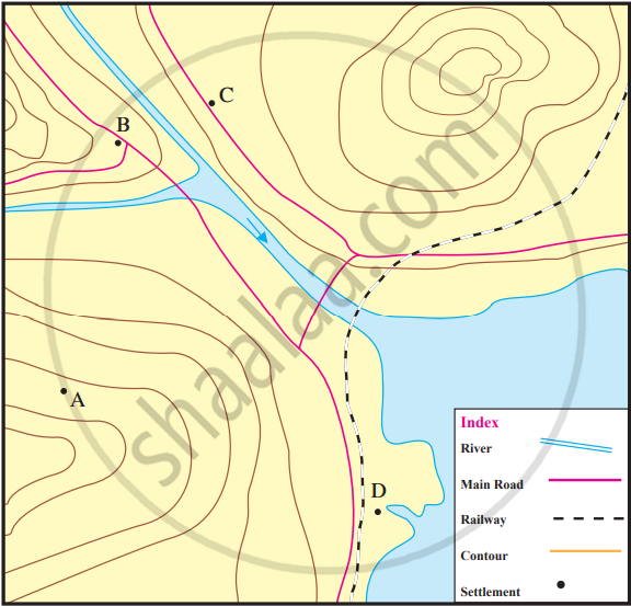
Study the diagram and identify the types of settlements.
- Settlement ‘A’ has 5-6 houses and the place does not have other facilities.
- ‘B’ has a high school, a big market, and a small theatre.
- ‘C’ has houses, farms, many shops, and small industries.
- ‘D’ is a natural harbour. Many industries have been established there.
* ‘C’ is a settlement that has developed along the roadside. Give two reasons of its location here.
Concept: undefined >> undefined
With the help of the internet, find the image of your village/city. On that basis, write about the type and characteristics of your settlement.
Concept: undefined >> undefined


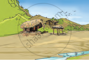
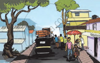
Observe the pictures given. Think and answer the following questions:
- What all can you see in the pictures?
- What are the familiar features?
- Which picture shows sparse settlements?
- Which picture shows agriculture?
- Which picture shows dense settlements?
- Which picture shows high rise buildings?
- From the following, assign suitable names to each of the pictures: Rural settlement, Tribal hamlet, Town, City
- Arrange the pictures according to the level of development in the settlements.
Concept: undefined >> undefined
How can the distribution of the height and landforms in a region be shown?
Concept: undefined >> undefined
To whom are the contour maps useful?
Concept: undefined >> undefined
What do you understand by observing contour lines?
Concept: undefined >> undefined
How will a contour map be useful for a farmer?
Concept: undefined >> undefined
If the contour lines are closer to each other, the slope is ______.
Concept: undefined >> undefined
The contour lines on the map represent ______.
Concept: undefined >> undefined
The slope can be understood from the distance between the ______.
Concept: undefined >> undefined
If the distance between two contour lines is more, the ______ is gentle.
Concept: undefined >> undefined
Identify the landforms in the following map.

Concept: undefined >> undefined
Observe this model and the map figure a and b given below it and answer the following questions.
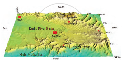

- In which direction does fort Purandar lie?
- What is the direction of the flow of the river Karha?
- In which parts are the hill ranges not observed?
- Which part of the map is not seen in the model? Why?
- In which direction does the altitude of the Katraj-Diveghat range decrease?
- In which direction are higher hill ranges located?
Concept: undefined >> undefined
