Advertisements
Advertisements
Give a geographical reason:
Slope is a major factor in mass wasting.
Concept: undefined >> undefined
Give a geographical reason:
Oxidation changes the size and colour of the rocks.
Concept: undefined >> undefined
Advertisements
Give a geographical reason:
Effect of mass movement will be greater along the western slope of the Sahyadri's than the eastern slope.
Concept: undefined >> undefined
A region is having an annual mean temperature of 5°C and an annual rainfall of 1000 mm. Can you comment upon the weathering and the type with the help of the following questions? Discuss in class.
- Which type of weathering will be dominant here?
- Where will such a region be found?
Concept: undefined >> undefined
On the basis of the given points, differentiate between weathering and erosion.
| Weathering | Erosion | |
| Definition | ||
| Causes/Agents | ||
| Effect/Results | ||
| Examples |
Concept: undefined >> undefined
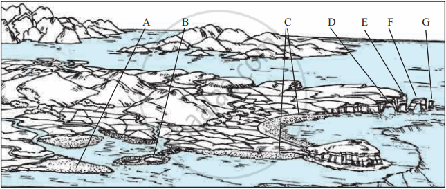
Look at the figure and identify the landforms at A, B, C, D, E, F, and G.
Concept: undefined >> undefined
- Have you ever thought why there is a difference in the skin color of various peoples in the world?
- Why all the people in the world do not eat the same food?
- Why there is a variety of clothing patterns and types too? Even our houses are different.
- How come flora and fauna are restricted to a particular region?
- Why different fruits are found in different places?
Concept: undefined >> undefined
Make a list of the human activities you think that are not influenced by climatic elements. Let us see how far you can proceed.
Concept: undefined >> undefined
Write the names of climatic regions according to the factors that dominate their characteristics.
| Latitudinal location | Winds and wind systems | Proximity to sea | a Continental location | Altitude |
Concept: undefined >> undefined
The graph in the figure shows the difference between the global average temperature of the twentieth century and global monthly temperatures from 1985 to 2015. Answer the questions given below:

- In which year is the difference the least?
- What is the difference between the mean temperatures of the twentieth century and temperature in 2015?
- Why do the temperatures differ in different months?
Concept: undefined >> undefined
Look at the following graph. Answer the following question.
- Which of these gases has the highest contribution?
- Which of these gases come from natural and man-made sources?
- Which activities are responsible for their emission?
- Out of these, whose emissions can be controlled by humans?

Global Greenhouse Gas Emissions
Concept: undefined >> undefined
Look at the graph in the figure and answer the following questions:

- What does the graph show?
- In which year is the change around 225 mm?
- What conclusions can you draw by seeing the graph?
- What correlation can be seen between this graph and the graph of rising temperatures?
Concept: undefined >> undefined
Collect information on the following and discuss in the class:
- Major journeys carried out by explorers in the last millennium
- Discovery of continents, countries, and islands
- Spread of culture, trade, and religions
Comment on how oceans have played a major role in all the three points mentioned above.
Concept: undefined >> undefined
Look at the figure and answer the following question.
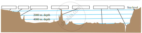
- What does the figure show?
- In which part of the figure is the ocean shallow? Which human activities can be carried out here?
- In which part does deposition of sediments occur?
- Where in the figure do you find islands formed due to submerged mountains?
- Label the figure with the correct names of landforms.
- Compare these features with the landforms on the earth.
Concept: undefined >> undefined
Find out the name and locations of islands located in India and list them in the above given categories.
Concept: undefined >> undefined
Complete the chain:
| A | B | C |
| 1) Continental Shelf | 1) deeper part | 1) Manganese nodules |
| 2) Oceanic microorganisms | 2) Abyssal plains | 2) Whales |
| 3) Oceanic Trenches | 3) fishing | 3) Sunda |
| 4) Vast Flat Area | 4) plankton | 4) Dogger Bank |
Concept: undefined >> undefined
Show the following on the map of the World:
- Chagos Range
- Mariana Trench
- Dogger Bank
- Mumbai High
- Sunda Deep
- Grand Banks
Concept: undefined >> undefined
Look at the figure and answer the following questions:

- What does this map show?
- Which continents and sub-continents are visible on this map?
- What lies between the continents?
- Chagos Plateau, Sunda Trench, Central Mountain range are a part of what?
- What are the conclusions you can draw after looking at the map?
Concept: undefined >> undefined
See the maps in Figures A and B. They show the pattern of ocean currents in the Indian Ocean during different seasons.
Study the maps carefully and answer the following questions.
- Identify the season each map is representing and name them accordingly.
- What difference do you notice in the direction of currents between winter and summer in the Northern part of the Indian Ocean?
- How many cold currents are there in the Indian Ocean? Name them.
- Why do you think the cold currents are fewer in the Indian Ocean.
- Which currents maintain the direction in both the season?
- Can you see any circulation in the currents of the Indian Ocean? What are such circulations called? If yes name the currents sequentially.


Concept: undefined >> undefined
Complete the chain:
| A | B | C |
| 1) Pacific Ocean | 1) Christmas | 1) Bab-al-Mandeb |
| 2) Chagos | 2) Atlantic Ocean | 2) Lakshadweep |
| 3) Ashmore | 3) Maldives | 3) Indian Ocean |
| 4) Hormuz | 4) Malacca | 4) Cocos |
Concept: undefined >> undefined
