ISC (Commerce)
ISC (Arts)
ISC (Science)
Academic Year: 2018-2019
Date & Time: 6th March 2020, 12:00 pm
Advertisements
- Answer Section A and B from Part I which are compulsory.
- Answer any four questions from Part II.
- Sketch maps and diagrams should be drawn wherever they serve to illustrate your answer.
Why is the location of India in the Indian Ocean considered to be significant? Give two reasons.
Chapter: [1] Locational Setting of India
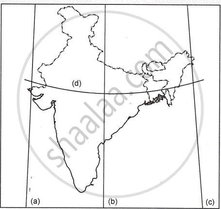
With reference to the extent of India, write the angular values of the points marked as (a), (b), (c) and (d) in the map given below:
Chapter:
Name the four Indian geological eras in their chronological order.
Chapter:
Briefly explain any two factors responsible for the depletion of forests in India.
Chapter:
Mention any two differences between the Bhabar and the Tarai regions.
Chapter:
Briefly explain the following terms :
(a) physiological density
(b) Conurbation
Chapter:
State two problems affecting the fishing industry in Bangladesh.
Chapter:
Name one mining centre of the following:
Mica in Andhra Pradesh
Chapter:
Name one mining centre of the following:
Iron ore in Odisha
Chapter:
Name the two terminals of the East-West corridor.
Chapter:
- Which is the largest agro-based industry in India?
- Give two reasons to explain why this industry is important to India.
- Name one industry which is dependent on the industry that you have named.
Chapter:
On the outline map of India provided :
(a) Mark and name the northernmost point of the Indian Union.
(b) Mark and label the Nilgiri Hills.
(c) Shade and label the Gulf of Khambat.
(d) Trace the course and label the river Mahanadi.
(e) Show with a single arrow and name the wind that brings rain over the coast of Tamil Nadu, during winters.
(f) Locate with a dot and name the capital city of Rajasthan.
(g) Mark and name the Nathula Pass.
(h) Mark and name the oldest oil-field of India.
(i) Mark with a dot and name the major port of Andhra Pradesh.
(j) Mark and label the hinterland of Chennai.
Note: All the map work, including legend (Index), should be done on the map sheet only.
Chapter:
Briefly explain the geological evolution of the Himalayas.
Chapter:
Explain, giving any two reasons, why the deltas of the river Mahanadi suffer from occasional floods.
Chapter:
Study the temperature and rainfall graph of station X given below and answer the questions that follow:

- Is the location of station X inland or coastal?
- What is the cause of a sudden fall of temperature in July, even though it is a summer month?
- Mention one main feature of the climate experienced by the station X.
Chapter:
Advertisements
How is the index of concentration useful in the study of the population?
Chapter:
Differentiate between natural growth of population and migratory growth of population.
Chapter:
Explain why sex composition is an important demographic attribute of the population in India.
Chapter:
Figures A and B given below show two types of settlement patterns that have developed in India.


Figure A Figure B
- Name the settlement patterns in Figures A and B.
- State one characteristic feature of each of the settlement patterns.
Chapter:
What are the two main components of urbanisation?
Chapter:
Briefly explain any two adverse effects of small and fragmented holdings on agricultural productivity.
Chapter:
State two ways in which forest areas in our country can be increased.
Chapter:
Mention three constraints explaining why cultivable wasteland is not being used for cultivation at present.
Chapter:
In which two ways are tube-wells better than ordinary wells as a form of irrigation?
Chapter:
With reference to canal irrigation, name one canal in each of the following states
(i) Uttar Pradesh
(ii) Punjab
Chapter:
(i) What is crop rotation?
(ii) Mention two reasons why crop rotation is necessary for India.
Chapter: [14] Agriculture
What is the importance of animal husbandry in Indian agriculture?
Chapter:
Differentiate between pelagic fish and demersal fish.
Chapter:
Name the following:
A geothermal energy plant in Himachal Pradesh.
Chapter:
Name the following:
An offshore oilfield in the country.
Chapter:
Name the following:
The nuclear power station in Tamil Nadu.
Chapter:
Advertisements
Explain two factors that affect inland waterways in India.
Chapter: [17] Transport and Communication
Give reasons for the following:
There is a dense network of railways over the North Indian Plains.
Chapter:
Give reasons for the following:
Peninsular Plateau has a high proportion of metalled roads.
Chapter:
Give reasons for the following:
A good transport network promotes industrial development.
Chapter:
Mention one advantage and one disadvantage of air transport.
Chapter: [17] Transport and Communication
Differentiate between Telecommunication and Mass Communication.
Chapter:
State any two ways in which radio can still be considered as a powerful means of mass communication in remote areas.
Chapter:
Mention two reasons for the development of the Bengaluru-Tamil Nadu Industrial Region.
Chapter:
Give three reasons to explain the development of the sugar industry in Maharashtra.
Chapter:
State two advantages that mini steel plants have over large integrated steel plants.
Chapter: [18] Industries
State any two advantages of tourism in India.
Chapter: [19] Tourism Industry
Mention any two characteristics of a planning region.
Chapter:
Distinguish between multi-level planning and single-level planning.
Chapter:
Explain giving two reasons why there is a need for planned development for a country like India.
Chapter:
Mention any two factors which have influenced the development of the Electronic City of Bengaluru.
Chapter:
Name two main districts of Silk production in Chhattisgarh.
Chapter:
With reference to Haldia Port, answer the following question:
Location of the port.
Chapter:
With reference to Haldia port, answer the following:
State the need for the development of this port.
Chapter: [11] Urban Settlements
Other Solutions
Submit Question Paper
Help us maintain new question papers on Shaalaa.com, so we can continue to help studentsonly jpg, png and pdf files
CISCE previous year question papers Class 12 Geography with solutions 2018 - 2019
Previous year Question paper for CISCE Class 12 -2019 is solved by experts. Solved question papers gives you the chance to check yourself after your mock test.
By referring the question paper Solutions for Geography, you can scale your preparation level and work on your weak areas. It will also help the candidates in developing the time-management skills. Practice makes perfect, and there is no better way to practice than to attempt previous year question paper solutions of CISCE Class 12.
How CISCE Class 12 Question Paper solutions Help Students ?
• Question paper solutions for Geography will helps students to prepare for exam.
• Question paper with answer will boost students confidence in exam time and also give you an idea About the important questions and topics to be prepared for the board exam.
• For finding solution of question papers no need to refer so multiple sources like textbook or guides.
