Advertisements
Advertisements
प्रश्न
Study the extract of the Survey of India map sheet no: G4357 - Map 2 and answer the following questions (Eastings 24 to 32, Northings 95 to 05):
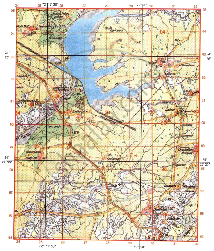
- What are the three types of Scales? Which among them is universally used?
-
- What do the black curved lines in four figure grid reference 2400 indicate?
- How is this feature formed?
-
- What is ‘Sheet Rock’?
- Give the four-figure grid reference of a ‘Sheet Rock’ in the map extract.
- Which quarter of the map extract has the lowest average height above mean sea level? Give reason for your answer.
-
- Identify two natural features in grid square in 2904.
- Identify two man-made features in grid square in 2998.
- What is the six-figure grid reference of the following:
- Δ 307?
- Lined Perennial well with a relative depth of 21 metres?
- Answer with reference to Sarod N.
- What is the nature of the river?
- What is the white patch inside the river?
- What is the direction of Jorapura (2498) from Mahudi Nani (2604) and from Dantiwada (2996), respectively?
- Name any two types of natural vegetation shown on the map extract.
-
- Identify the blue line passing through four figure grid reference 2402.
- What type of embankment is built across Sipu River to form the reservoir?
कारण सांगा
अति संक्षिप्त उत्तर
Advertisements
उत्तर
- The three types of scale are:
Representative fraction, Statement scale orverbal scale and Graphical or Linear scale.Representative fraction is universally used. -
- They indicate broken ground.
- Broken ground is formed by erosion during heavy rainfall due to flooding.
-
- Sheet rock - Large areas of rock where theoverlying soil layers have been eroded.
- The four-figure grid is 2500.
- South-West quarter
Reason: The Sipu River runs toward the southwest, with spot heights decreasing from 194 to 168 and contour heights decreasing from 180 to 160. -
- Seasonal stream, sand dunes, brokenground, seasonal river with perennialwater channel
- Temporary hut, cart track
-
- 307963
- 258019
-
- Seasonal river
- Island in a river or river island
- Jorapura from Mahudi Moti is South-West.
Jorapura from Dantiwada is North-West. - Open Jungle, Open Scrub and Scattered trees
-
- Perennial canal with Aqueducts.
- Earthwork embankment
shaalaa.com
या प्रश्नात किंवा उत्तरात काही त्रुटी आहे का?
